Quantcast
Channel: Time Travel Ireland

The River Walk, Trim, County Meath

$
0
0
If you plan your walk in the evening you'll be rewarded with breathtaking sunsets over the Boyne and medieval buildings
The town of Trim in County Meath is the site of the largest Norman Castle in Ireland. It was built by the powerful Hugh de Lacy in the late twelfth century. Although Trim Castle is a popular spot, few visitors realise that there is a wonderful River Walk adjacent to the castle that is one of the nicest strolls in Ireland. The route is popular with locals, and every time I’ve taken it I’ve seen a number of joggers, dog-walkers and families enjoying this wonderful amenity.

Before you set off though try and fit in a tour of Trim Castle itself as you will enjoy one of the best guided tours in Ireland (disclaimer, I used to work as a guide here so I’m a little biased). I’ll cover the castle and its history in a separate blogpost, it is undoubtedly one of my favourite heritage sites.

You can enjoy wonderful views of the castle from the vantage point of the River Walk
When you have finished your tour of the castle, go back to the carpark and cross the small wooden bridge over the Boyne. As you cross the wooden bridge, take a moment to look at the stone bridge that will be on your left. This bridge was constructed some time between 1330 – 1350 and it still carries traffic today, they certainly built to last in medieval Ireland!

The fourteenth century bridge over the Boyne
The Yellow Steeple
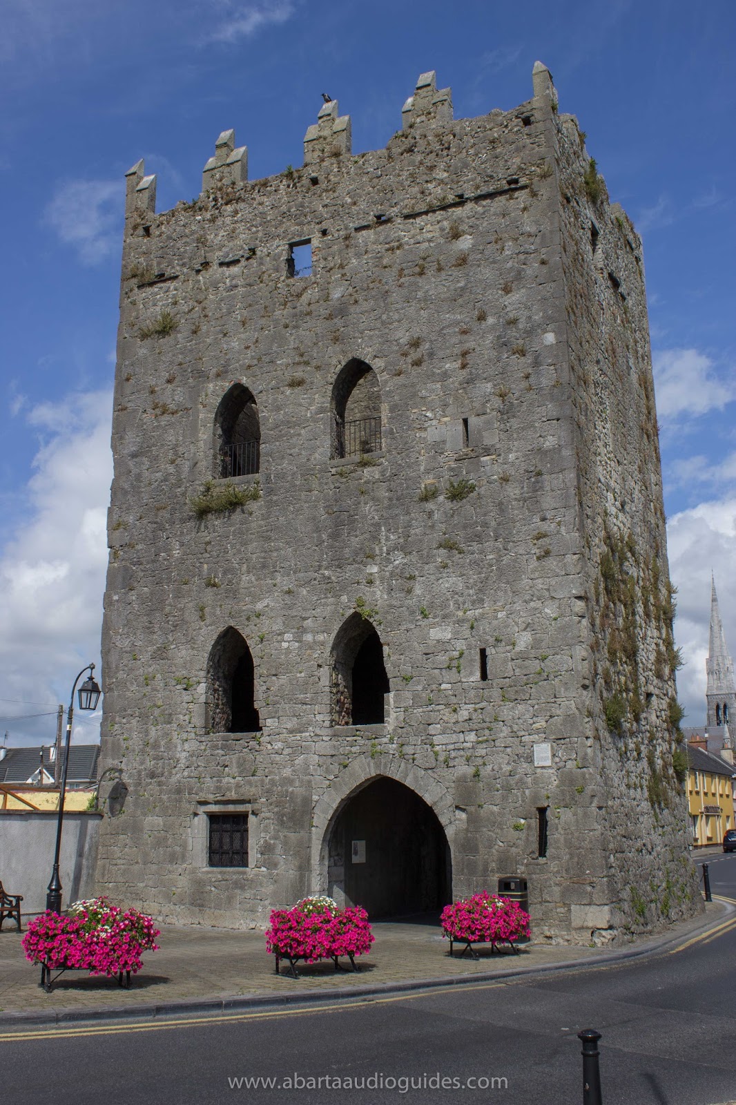
The tall stone tower opposite the castle is known locally as The Yellow Steeple. It too dates to the fourteenth century (thought to be constructed around 1368–70). It was the bell tower of the Augustinian Abbey of St. Mary’s that once stood opposite the castle. At 40m (131ft) tall, the Yellow Steeple is said to be the tallest medieval building still standing in Ireland. There are little visible remains of the other buildings of St. Mary’s, though Talbot’s Castle, the fine fortified townhouse to the left of the Yellow Steeple, is thought to have incorporated abbey buildings. Talbot’s Castle was built shortly after the Dissolution of the Monasteries in the 1540s. It was said to have been once the home of the famous satirist Jonathan Swift, author of Gulliver’s Travels. He was the vicar of Laracor on the outskirts of Trim in 1670.
Talbot's Castle, once the home of Jonathan Swift

The Sheep Gate (right of foreground) with Trim Castle in the background
The stone gate that straddles the path is called the ‘Sheep Gate’. Like the majority of medieval towns, Trim was surrounded by a defensive wall. As well as providing extra fortifications to protect the townspeople at times of conflict, the wall also served as a clear boundary between the town and countryside, where people entering the town could expect to be under different rules and regulations. The gateways served as control points, where tolls and taxes could be easily collected. The low stretch of stone wall running up the slope from the Sheep Gate is the remains of the once strong defensive walls, and the Sheep Gate itself is the only surviving medieval gate into Trim.

The path of The River Walk, winding its way alongside the Boyne
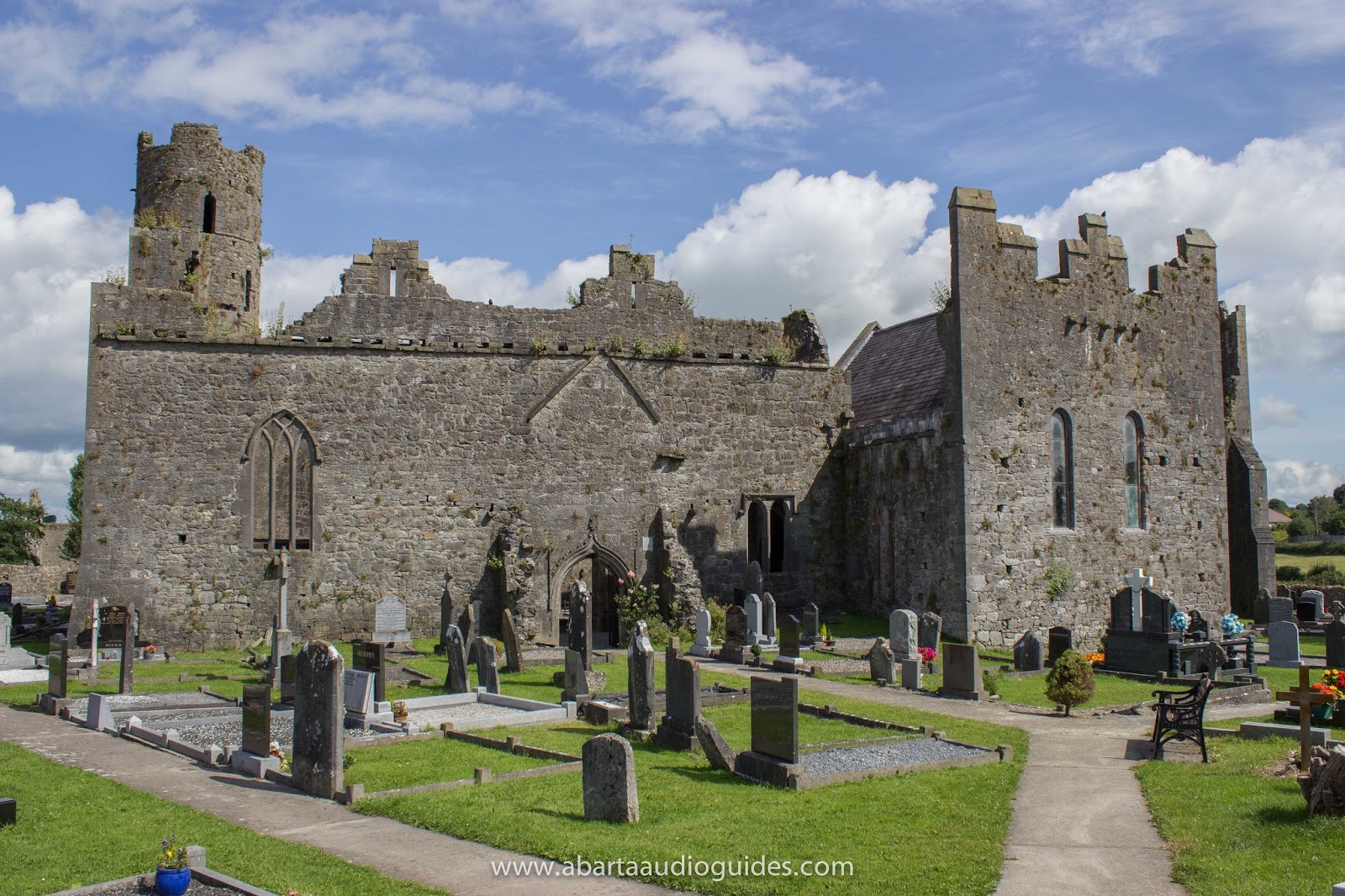
As you continue along the path following the bank of the river you can find a number of information panels that inform you about life here in the medieval period. After walking for around 15mins you will eventually come to the The Cathedral of Saints Peter and Paul at Newtown. The Cathedral was founded by the Norman Bishop, Simon de Rochfort, in around 1206.
The Nave of the Cathedral catching the last rays of the sun. 

Lovely medieval sculpture of an angel inside the Cathedral of Saints Peter & Paul

Although only parts of the nave and chancel survive today, it is easy to get the impression of just how massive this cathedral would have been. You can still see many of the fine decorative flourishes in the stonework, and it has lovely lancet windows. The piscina where the priest used to wash the holy vessels during the mass is also still well preserved.

The 'Tomb of the Jealous Man' at Newtown Trim
Just beyond the Cathedral remains you can find a small parish church that probably dates to the later fifteenth century. This site is famous for the remarkable 16th Century tomb of Sir Lucas Dillon and his wife, Lady Jayne Bathe. The two stone effigies on the tomb are separated by a sword of state. The tomb is known locally as 'The Tomb of the Jealous Man and Woman', it is believed that instead of signifying the sword of state, the sword actually represents Sir Lucas' displeasure at his wife for having an affair, forever separating the two. It is believed that the tomb possesses a cure for warts and skin complaints. Rub your wart on a pin and leave the pin on top of the tomb, as the pin rusts the wart withers and falls off. I cannot speak personally for whether this works, but I did notice a large number of pins on the tomb!

The Priory Hospital of John the Baptist.
Further along the path and just over a small medieval bridge, you come to remarkable ruins of The Priory and Hospital of St. John the Baptist. The Priory was founded in the early thirteenth century by Simon de Rochfort for the Order of the Crutched Friars (Fratres Cruciferi). As well as being a monastery and guesthouse for pilgrims, the site also served as a hospital. The Order of the Crutched friars were just one of a number of religious orders that were brought to Ireland by the Normans following their invasion. They also brought the Knights Templar, the Hospitalliers and Trinitarians, as well as strongly supporting the expansion of religious orders like the Augustinians, Benedictines and Cistercians who already had a foothold in Ireland prior to the Norman invasion.
Inside the Priory Hospital of St. John the Baptist
The site was excavated by David Sweetman in 1984, he discovered the remains of a fifteenth century rood-screen that separated the nave from the choir, and a doorway in the gable end of the nave. He also found the remains of a tower leading to a room over the sacristy and part of the original domestic range to the north-east of the choir. Today you can still find the nave and chancel and a striking three-light window in the eastern wall. The large rectangular three-storey tower is 15th century, and was likely to have been domestic quarters.

You can still make out sections of the later 16th century enclosing walls that surround the site, and one small corner turret is still standing today in the western side of the field. The priory was dissolved during the Reformation in 1541, and was converted to being a private residence.

All of these sites are fantastic to explore, the walk from the castle carpark to the Priory Hospital will take around 30–35mins and there is a great old pub, Marcey Reagan’s directly across from the last stop so you can reward yourself before retracing your steps back along the path.

If you’d like to keep up with daily images and information about Ireland’s fantastic heritage sites please consider following Neil’s company Abarta Audioguides on Facebook, Twitter, Instagram or Google+.

If you’d like to support us please consider downloading an audioguide from abartaaudioguides.com: they are packed with great facts, information, stories and legends from Ireland’s iconic sites. They are designed to be fun and informative whether you are visiting the sites or from the comfort of your own home, so if you are looking to escape to the Court of Brian Boru the next time you are doing household chores, download one of our guides and let Abarta whisk you off to ancient Ireland!

All images © Neil Jackman/Abarta Audio Guides


Some Sources and Recommended Reading:

Halpin, A and Newman, C. 2006. Ireland: An Oxford Archaeological Guide (Oxford University Press, New York).

Potterton, M. and Seaver, M. (eds) 2009. Uncovering Medieval Trim, Archaeological Excavations in  and around Trim, Co. Meath. (Four Courts Press, Dublin).

Potterton, M. 2005. Medieval Trim: History and Archaeology (Four Courts Press, Dublin)


Seahan Megalithic Tomb, County Dublin

$
0
0
The exposed chamber of one of the tombs, with the larger cairn topped by an Ordnance Survey point in the background

On Saturday (15th March 2014) we visited Seahan, another of the megalithic tombs of the Dublin and Wicklow Mountains. At Seahan [sometimes spelled as Seehan] you can find the remains of two large stone cairns. They probably date to the Neolithic period, around 5,000 years old, a time when people first began to clear the ancient forests to create fields for farming. They are thought to be the remains of passage tombs, a type of burial monument that appears as a round mound of stones or earth, ringed by large stones set on their edges to form a kerb. Parallel lines of upright stones formed a passageway leading to a chamber which usually contained the remains the dead. 

One of the cairns on Seahan has a very clear kerb of stones surrounding it, but it has been disturbed, possibly in antiquity. It is situated adjacent to a larger cairn that has an ordnance survey point added to its summit. Its possible that some of the stones of the exposed tomb were used in the construction of this large cairn. Archaeologist Christiaan Corlett suggests that perhaps this raises some interesting questions about the relationship of the two tombs – perhaps the people constructing the larger cairn deliberately ‘slighted’ the older tomb to construct a new larger cairn. Perhaps as a way of symbolising their ascendancy over the people who are interred within the smaller tomb and their descendants who built it.
The Ordnance Survey point that has been added to the top of the larger cairn on Seahan.
The cairns on top of Seefinghan (left) and Seefin (right) visible from the tombs of Seahan
Seahan appears to be part of an extended series or cemetery of passage tombs that cover a number of peaks in the area. From Seahan you can clearly see the cairns on top of Seefingan and Seefin. Building these tombs so high in the Dublin and Wicklow mountains must have been an incredibly difficult undertaking in the Neolithic period even though there is an abundant supply of stone on top of the hills. The peaks of these hills are all around 650m – 750m above sea level, so why would they have constructed these elaborate and large stone tombs up here? 

Expansive views over Dublin from the summit of Seahan
We can never say with certainty, but perhaps like a lot of cultures around the world, they believed that to be buried in these high places was to be closer to their gods. Personally though, I think that it was a statement of ownership over the landscape. From this high vantage point the whole of South County Dublin and Wicklow is visible. Green fields, rivers, lakes. Perhaps they believed that any newcomers to this fertile territory would see the very visible tombs in the distance and know that the people living here have done so for millennia. Or maybe they believed that by placing their ancestors far above the low lying lands of the living, the shades of their forebears could watch over them from their tombs. For those interested in prehistoric archaeology, or those who love a bit of hillwalking, or those who just want to see some of the finest views in Ireland, Seahan is a real must-see. 

The Famine Cross, take the road to the left of this monument.
I strongly recommend you use OSI Discovery Series Mapping Numbers 50 and 56 to help you find the tomb easily. To get there exit the M50 at Junction 12 Firhouse. Travel on the R113 towards Oldbawn. Take the left turn for the R114 signed for Bohernabreena. Continue straight on this road, staying right at the slight fork at Bohernabreena. Drive past the golf club on your left and take the road to the left of a famine cross you will see on the left hand side of the road. Continue on this road for about 5 minutes. On a clear day you will see Seahan on top of the mountain to your left and Seefin and Seefingan ahead. Seahan is separated from Seefinghan and Seefin by the Army Rifle Range, if you see signs for that you have gone too far. There is a parking area below Seehan in front of large boulders. Park here and walk along the path. Take the first left on this path - this will lead you up to the summit of Seehan. We had great weather for our visit, but I wouldn’t recommend the trip in poor conditions. It was about a 25–30min fairly easy stroll up the Mountain to the site, but good boots are recommended. Above all though, please do be aware of the Army Rifle Range and respect their warning signs! 


If you'd like to support us please check out our acclaimed series of audioguides to Ireland’s heritage sites, they are packed with original music and sound effects and a really fun and immersive way of exploring Ireland’s past. They are available from www.AbartaAudioGuides.com.
If you’d like to receive daily updates and images of great heritage sites then please consider following us on Facebook, Twitter and Google+.


Some Sources and Recommended Reading:

Corlett, C. 2012. The Megalithic Tombs of South Dublin, Archaeology Ireland Heritage Guide No.57. (Wordwell, Ireland)
Cooney, G. 2000. Landscapes of Neolithic Ireland (Routledge, London)
Waddell, J. 2000. The Prehistoric Archaeology of Ireland (Wordwell, Ireland)


All photographs and text © Neil Jackman / www.abartaaudioguides.com
The stunning landscape of the Dublin Mountains, like a different world and less than 30mins from Dublin!

Dowth Passage Tomb, County Meath

$
0
0
The Boyne Valley is one of the most important archaeological landscapes in the world and this region sheltered in a bend of the River Boyne, known as Brú na Bóinne (meaning Palace of the Boyne) is home to three massive Neolithic passage tombs, Newgrange, Knowth and Dowth. A number of smaller tombs and features of huge importance are also contained within this area, but for this blogpost I’ll be focusing on Dowth – perhaps the least understood of the three major tombs. 

The silver ribbon of the Boyne visible from Dowth
Dowth is located around 2km north-east of Newgrange. Unlike Newgrange and Knowth, Dowth has never been properly excavated by archaeologists so there is far less known about the site. However in the middle of the nineteenth century, an extremely large hole was dug into the top of the mound.


Dowth is thought to date to around 5000 years old. It measures approximately 85m (280ft) in diameter and is ringed by 115 kerbstones, some of which display megalithic art. Two tombs are known at the western side of the large mound at Dowth and the setting sun in winter seems to illuminate the southernmost of these. Unfortunately on the day we visited we couldn’t access the passageways of the tombs as they were behind locked gates. The more northerly tomb has an 8m (26ft) long passageway that leads into a cruciform shaped chamber with an annexe leading off it. It also has an early medieval souterrain, probably dating to around the 10th century leading off the passageway. This shows that the tomb was still an important place in the early medieval period and possibly indicates a connection to an ancient monument with folkloric supernatural qualities. The southern passage has a circular chamber with a diameter of 4m (13ft). 

Unlike Knowth there are no satellite tombs immediately outside the great tomb at Dowth, but there are outlying tombs around 0.5km away, and a massive earth embanked henge is located to the east though there is no public access to that site.


A view down the northern passageway through the locked gate
A view down the southern passageway through the locked gate
The entrance to the southern passageway with a large kerbstone bearing cupmarks directly in front of the entrance


Dowth was known in early literature as Dubad and Sid mBresail (the otherworld mound of Bresal). The medieval manuscripts known as Dindseanchas explains how Dowth (Dubad) got its name. They tell the story of how all the men of Ireland were commanded by the King to come together for just one day to build a tower that would reach the heavens. The King's sister secretly used magic and stopped the sun in the sky so that there would be an endless day. As time wore on the men of Ireland became exhausted and realised that they had been tricked. However the magic spell was broken when the King and his sister committed incest. Darkness swiftly covered the land and work on the great mound was abandoned, it was said that Dubad (darkness) would be the name of this place from that day. In his brilliant new publication Archaeology and Celtic Myth, Professor John Waddell of NUI Galway notes the co-incidence that this legend reflects control over time and that archaeological excavation has revealed solar ritual and astronomical reflection in the tombs construction. Giving credit to Professor MJ O’Kelly and J. Carey’s hypothesis that these tales and legends recorded in medieval times might echo the beliefs of Neolithic tomb-builders millennia before.

If you look very carefully you can make out megalithic art on this kerbstone
The construction of the massive passage tombs of the Boyne Valley like Dowth, Knowth and Newgrange possibly indicate a larger-scale social identity. The physical size of these monuments and their complexity in construction suggests that there was an ability to mobilise hundreds of people to work on the tombs. This gives an indication of a concerted effort by a large group. Perhaps suggesting that these early farmers were forming large community groups for mutual support and ritual practices.

Dowth is free to access and there are no on-site guides, though the nearby Brú na Bóinne visitor centre gives a really good overview of the archaeology and history of these fascinating sites. A day out to the visitor centre to see Newgrange and Knowth and then a short drive to see Dowth is one of the most atmospheric and rewarding days you can have. I highly recommend it! For more information on the Visitor Centre please see here.

I hope you enjoy our blog, and if you have any suggestions for historical sites you’d like me to cover please do get in touch at info@abartaaudioguides.com. If you'd like to support us please check out our acclaimed series of audioguides to Ireland’s heritage sites, they are packed with original music and sound effects and a really fun and immersive way of exploring Ireland’s past. They are available from www.AbartaAudioGuides.com.
If you’d like to receive daily updates and images of great heritage sites then please consider following us on Facebook, Twitter and Google+.


Some Sources and Further Reading

Cooney, G. 2000. Landscapes of Neolithic Ireland (Routledge, London)
Cooney, G. and Grogan, E. 1999. Irish Prehistory; A Social Perspective (Wordwell, Wicklow).
Herity, M. and Eogan. G. 1996. Ireland in Prehistory (Routledge, London)
Waddell, J. 2014. Archaeology and Celtic Myth (Four Courts Press, Dublin).

St. Doulagh's Church, County Dublin

$
0
0

If you’d like to receive daily updates and images of great heritage sites then please consider following us on Facebook, Twitter and Google+.

The interior of the 19th century part of the church
Every now and again a heritage site really surprises me. We were out on Friday looking at sites in the North County Dublin / Fingal region, and we really enjoyed visiting the town of Swords with it’s fine round tower and castle. After a lunch stop at Malahide Castle, we decided to stop at a church called St. Doulagh’s that was nearby. We thought it would be a ten minute stop but we were extremely lucky that we bumped into Victor, who works at the site and he gave us a fascinating guided tour of a truly remarkable building. 

The medieval font
St. Doulagh’s is still used as a Church of Ireland place of worship, and on first entering the church it appears as a very nice, but not particularly unusual place, with fine oak vaulting on the ceiling and the stately but welcoming feel typical of a lot of Church of Ireland buildings. However the first clue of the buildings antiquity was the plain medieval baptismal font that is still in use today. And when we were led into the vestry in the old part of the church, the sheer history of the building became very apparent. 


A medieval piscina and fragments of a medieval sculpture in the vestry
A monastery is believed to have been founded here by the little-known, seventh century anchorite hermit Saint Doulagh. However the earliest historical reference to the church dates from the ninth century, in the Martyrology of Oengus. In that text the church is called Duilech Cain Clochair. The site has many of the features of an early medieval monastery, in the 1980s excavations by the archaeologist Leo Swan discovered a number of burials and the enclosure ditches that once surrounded the monastery. 


The church building is a fascinating mish-mash of a number of different periods, and it can be extremely difficult to work out which features date to what period. The eastern end of the building is thought to be the earliest. It has a very steeply vaulted stone roof and has a croft or living quarters for the monks. It is a little reminiscent of the vaulted stone roof of St. Kevin’s Church at Glendalough, or St. Colmcille’s House in Kells. This part of the building is thought to date to the twelfth century, making St. Doulagh’s the oldest stone-roofed church still in use as a place of worship. The tall central tower is thought to have been added in the fifteenth century, and you can access a number of the rooms from the exceptionally narrow spiral staircase
The very narrow spiral staircase
In the entrance hall there is a small ‘hermit’s cell’ which is reputed to be the burial place of St. Doulagh himself. From there you can access the handsome 19th century church that adjoins the older building. 

In the grounds of the churchyard you can find a lovely octagonal building covering St. Doulagh’s Holy Well and it is a charming and atmospheric spot. The interior was covered with frescoes in the early seventeenth century, painted in 1609 by a Mr Fagan, of Feltrim, though Victor the guide informed us that they were destroyed in the aftermath of the Williamite Wars. 

Just behind this well you can find another well dedicated to St. Catherine. It appears as an underground bath enclosed by a rectangular vaulted building, but this one is unfortunately not accessible at present. Just on the outside of the site near the entrance you can find an early medieval plain granite cross on a modern stepped-base. This was said to have been moved from the inside of the churchyard in the late 18th century. 

I strongly recommend a visit to St. Doulagh’s, it is a really fascinating building with a great atmosphere. St. Doulagh’s church is located at Balgriffin, on the Malahide Road, some 600 metres north of Balgriffin Cemetery. It is on the bus route 42 or 43 from Dublin City Centre.
St. Doulagh's Well
The early-medieval granite cross
Tours are available from May to September on Sundays from 2.30pm - 5.30pm. Tours can be arranged at other times for school, families, historical societies and heritage groups by contacting The Friends of St Doulagh's, see their website for more details: http://www.fingaldublin.ie/interior-pages/activities-attractions-amp-conference/castles-churches-and-towers/st-doulaghs-church/

I hope you enjoy our blog, and if you have any suggestions for historical sites you’d like me to cover please do get in touch at info@abartaaudioguides.com. If you'd like to support us please check out our acclaimed series of audioguides to Ireland’s heritage sites, they are packed with original music and sound effects and a really fun and immersive way of exploring Ireland’s past. They are available from www.AbartaAudioGuides.com.
If you’d like to receive daily updates and images of great heritage sites then please consider following us on Facebook, Twitter and Google+.


Some Sources and Further Reading

Baker, C. 2010. Antiquities of Old Fingal (Wordwell, Dublin) 

Harbison, P. 1982. St. Doulagh’s Church (in Studies: An Irish Quarterly Review, Vol. 71, No. 281)

Ormond Castle, County Tipperary

$
0
0

If you’d like to receive daily updates about great heritage sites then please consider following us on Facebook, Twitter andGoogle+.

Ormond Castle in Carrick-on-Suir, County Tipperary, originally dates to the fourteenth century. It is named after the Butler family, a highly influential and powerful Norman dynasty who became Earls of Ormond. The progenitor of the family in Ireland was Theobald Walter who came to Ireland in the aftermath of the Norman Invasion in the late twelfth-century. He was rewarded for his service by being granted vast lands in the South-East of Ireland, particularly centred around Counties Tipperary, Kilkenny and parts of Waterford. He was also given the title Chief Butler of Ireland, who had the honour of personally serving the King on state occasions, and with this came the right to levy his own tax on all wine imports into Ireland – as the Normans were known to like a tipple this ensured that Theobald Walter and his successors became very wealthy indeed!

In 1315 Edmund FitzWalter (6th Chief Butler) was granted the Lordship and Manor of Carrick by King Edward II, and his son James made the advantageous marriage to Eleanor de Bohun, a granddaughter of the King. By the middle of the fourteenth century, the Butlers were Earls of Ormond and had cemented their position as one of the wealthiest and most powerful dynasties in Ireland.

The castle at Carrick-on-Suir is thought to have an early origin, but the remains visible today largely date to later than the fourteenth century. In the grounds you can see the ruins of a medieval bawn (a fortified walled enclosure), with two tall fourteenth or fifteenth century towers. One of the towers is in ruins, while the other tower (thought to be the earliest of the two) is still well-preserved. If you look closely at the ruined tower you can still see features like the ornate fireplace that probably dates to the fifteenth or early sixteenth century [a noisy family of ravens have made one of these towers their home, and their calls certainly add atmosphere to the site]. Other buildings in the area exist only at foundation level, though it is possible to see the remains of the large bricked up Water Gate in the exterior wall. In the medieval period, the River Suir flowed at the base of the castle walls, and the River Gate allowed goods and people to be transported easily up and down the River to the other major centres nearby at Cahir, Clonmel and Waterford.

The Tudor Period was a turbulent time in Irish history. An uprising by the Butler’s long time rivals, The Fitzgeralds, had just been defeated, and King Henry VIII had become the first English Monarch to declare himself ‘King of Ireland’. He began a process of plantations and conquest that was continued after his death, during the reigns of Mary and then Elizabeth. During this chaotic period, Thomas Butler, Earl of Ossory and 10th Earl of Ormond succeeded to his lands and titles in 1546 when he was just fifteen years old. Thomas had grown up at the English Court, and was seen as a faithful friend to the Crown. He was a personal friend to the young Elizabeth (and some suggest perhaps their friendship was more romantic than platonic) and he shared a tutor with the future King Edward VI. Following King Henry VIII’s death, Thomas Butler was present at the Coronation of the young King Edward and he was proclaimed as a Knight of the Order of Bath, a very high honour. Following Edward’s death at a young age, he remained at court during Mary’s reign and rose to high favour and prominence when Elizabeth became Queen. She named him Lord Treasurer of Ireland, a position that brought great wealth and prestige. 

He returned to Ireland, where he was thought of favourably, though he was considered to be ‘wholly English’ by the locals. He fought a number of bloody campaigns against the rebellious O’Moore’s of County Laois. However, despite occasionally earning the displeasure of the English Court due to ongoing feuding with the Fitzgeralds, Thomas [or Black Tom as he became known] maintained the good favour of the Crown. He was awarded a number of titles; President of Munster, Lord High Marshal of Ireland and Commander in Chief of Her Majesty’s Forces in Ireland.

It is said that he had the handsome Manor House of Ormond Castle constructed in preparation for a planned visit by Queen Elizabeth the Ist. However she never journeyed to Ireland to see this splendid building. This building is Ireland’s finest surviving example of an Elizabethan Manor House, and many of its architectural styles reflect the English influence. Originally, its handsome stone walls would have been covered with a plaster render and whitewashed in the fashion of the time. The building faces outwards onto what would have been a large park with a grand carriageway.
Today you can enjoy a guided tour around this building (though unfortunately no interior photographs are permitted). You can enter a number of the rooms, most impressively the Long Gallery, and you’ll encounter features like musket-loops, showing a formidable defensive, as well as fashionable, design. There are a number of pieces of period furniture, though none are original to the building. They do give a good sense of the style and furniture of the period. Perhaps most impressive of all is the rare plaster stucco friezes that depict the coat of arms of the Butler Family as well as griffins, falcons and portrait busts of Elizabeth Ist. You can also see impressive grand fireplaces in this stately room that once would have been filled with portraits and tapestries, leaving visitors to Ormond Castle in no doubt about the wealth and taste of the Earl of Ormond.
Facing towards the now blocked up arch of the Water Gate

Gradually the Butler family began to focus their attention and money on their other residences at Kilkenny Castle and Dunmore House. By the end of the seventeenth century, Ormond Castle was leased to tenants like Sir Ralph Freeman and his wife, and a group of French merchant families. A number of changes and alterations are believed to have been carried out at this time. In the eighteenth century, a solicitor named Mr Wogan who was a tenant at the castle levelled many of the ancillary buildings and began to modernise the Manor House. Gradually, Ormond Castle began to fall into disrepair. It was taken into OPW care in the 1940s, and a long programme of restoration was initiated.

The Castle is open free of charge to visitors daily from; 6th March - 2nd September. Access to the interior is by guided tour only, and I strongly recommend you take the fascinating tour to see the impressive long gallery, and to get a sense of life in Tudor period Ireland. For more information please see http://www.heritageireland.ie/en/South-East/OrmondCastle/. The site is one of the key stops along The Butler Trail, a great new initiative. Please see here for more information: http://www.discoverireland.ie/thebutlertrail


Thank you for taking the time to read our blog, if you’d like to support us please consider downloading one of our acclaimed series of audioguides to Ireland’s heritage sites, they are packed with original music and sound effects and a really fun and immersive way of exploring Ireland’s past. They are available from AbartaAudioGuides.com.

If you’d like to receive daily updates about great heritage sites then please consider following us on Facebook, Twitter and Google+.


All photographs © Neil Jackman /abartaaudioguides.com

Derrynaflan, County Tipperary

$
0
0
If you’d like to receive daily updates about great heritage sites to visit in Ireland then please consider following us on FacebookTwitter  and Google+.

Derrynaflan, also known as Gobán Saor’s Island, is situated in the middle of Littleton bog in County Tipperary. The name derives from the Oak Wood of the Two Flanns, a reference to two prominent clerics who lived here during the ninth century. It has over a thousand years of history as an ecclesiastical settlement – from as far back as the early medieval period to the 1700s.
The site first appears in our historical records when a monastery was said to have been founded here by Saint Ruadhan of Lorrha in the sixth century. Derrynaflan reached its zenith in the eighth and ninth century, when it became home to the Celi Dé (or Culdee) movement. This Christian sect were noted for their very austere way of life.

Derrynaflan is reputed to be the burial place of An Gobán Saor (Gobán the builder), a famed architect, stonemason and builder of churches in Ireland in the decades around 600 AD. He is said to have been born near Malahide, Co Dublin in 560 AD. A wealth of folklore abounds concerning the life of An Gobán.

One tale tells how on one occasion he was building a monastery, and as he neared completion, the monks decided to lower his wages and cheat him of his dues. Gobán refused to negotiate, so the monks took away all his ladders and scaffolding until he agreed, leaving him trapped high on the building. This did not deter Gobán though, he simply began to throw down stone after stone of the building, saying it was an easy way as any to descend, the monks reluctantly relented and paid him the agreed fee.
The interior of the church
Another story concerns his shrewd wife Ruaidhseach. Gobán and his son were labouring for seven years to build a fine castle for a king. The wily king planned to have them killed when they finished it so they could not build as fine a fortress for any of his rivals. Gobán heard of his wicked plans and sent word to the king that he couldn’t finish the castle without a particular tool called a “crooked and straight”.

Bullaun Stone inside the church
The King, fearing treachery, would not allow Gobán and his son to leave to fetch the tool, so he sent his own son in their place. What the king did not guess, was that the ‘crooked and straight’ was actually a warning code for his wife, Ruaidhseach. When the Prince came demanding the ‘crooked and straight’ she told him it was at the bottom of a deep casket. When the Prince bent over to find it she quickly threw him in and sealed the casket, sending word to the King that if he wished to see his son again then he should release Gobán and her son which he promptly did. Three graveslabs on the eastern side of the island are said to mark the burial place of the Gobán and his family.

The land for Derrynaflan was probably granted by the powerful Eoganacht dynasty from their base in Cashel, however when the Eoganacht’s power began to wane by the end of the ninth century, the monastic community at Derrynaflan also went into decline.

The site was reinvigorated during the twelfth century, and the ruined church at Derrynaflan represents these two different periods. The small single-roomed church of the early medieval period was incorporated into a larger nave-and-chancel church in the twelfth century. This was a traditional layout during the medieval period, the chancel was the part of the church which housed the altar and where the priests, monks or clergy would have sat during mass, while the nave was for the common people. Outside the church you can see one wall of an enclosure nearby. A small Franciscan community continued largely unnoticed on the island between 1676 and 1717. This was during a period of suppression of the Catholic Church in Ireland, when the harsh Penal Laws held sway, following the Cromwellian Conquest and Williamite Wars.

In 1980 an incredible hoard of ecclesiastical metalwork was discovered nearby, including a beautiful silver chalice accompanied by a patten and wine strainer. These objects were thought to have been hidden for safekeeping sometime in the 9th or early 10th century, but never recovered. Perhaps the person who hid them was killed or captured in a raid by Vikings or Irish warriors from a rival tribe. These magnificent artefacts are now on display in the National Museum of Ireland on Kildare Street. 
The magnificent silver chalice of Derrynaflan
In recent years, life has begun to return to the old church site of Derrynaflan, as dawn mass on Easter Sunday morning on the island has become an annual event. To hear more of the story of Derrynaflan try our free MP3 audioguide, available from here

To get to Derrynaflan from the Laffansbridge direction, take the R691 at Laffansbridge. Turn left here (signposted for Cashel). After approx. 1.5 km turn right off this road onto the road signed L5402, which is a narrow third-class road. Follow this road for 2 km and then turn right (no signpost) on a laneway into the old village of Lurgoe, about 1km from Derrynaflan. It is possible to drive further from this point, but the laneways are narrow and unpaved and you will need to open and close several gates, so proceeding from here on foot is recommended. If you are at Horse & Jockey, just after the Hotel, turn left (signpost for Ballinure) and 200m down this road, take the second left junction. Continue along this road for 2.5 km. A laneway to the right leads towards Derrynaflan. It is recommended that you park here and proceed on foot southwards to Derrynaflan Island. 


Thank you for taking the time to read our blog, if you’d like to support us please consider downloading one of our acclaimed series of audioguides to Ireland’s heritage sites, they are packed with original music and sound effects and a really fun and immersive way of exploring Ireland’s past. They are available from AbartaAudioGuides.com.

If you’d like to receive daily updates about great heritage sites then please consider following us on Facebook, Twitter  and Google+.


Killeshin, County Laois

$
0
0
If you’d like to receive daily updates about great heritage sites to visit in Ireland then please consider following us on FacebookTwitter and Google+.

The remains of the monastic site at Killeshin really is one of Ireland's best hidden gems. It was originally founded in the sixth century by St. Dermot, but it was St. Comhdan who became the patron of the site.

Killeshin had a turbulent history with many accounts of raids by warring Irish tribes, particularly in the 11th century. It was plundered and demolished in 1041, and it is recorded that Diarmuid, son of Mael na mBó, was responsible. He was lord of the tribe known as the Ui Ceinnsealaigh who were mortal enemies of the Ui Bairrche tribe that held the lands around Killeshin. It is reputed that Diarmuid tore down or ‘broke’ the oratory on the site, killed over one hundred people and took hundreds more as slaves. More desecration was recorded in 1077, when the monastery was again raided and several yew trees were burned. This was a clear act of defiance and desecration as yew trees were often planted by monks to mark the sacred boundaries of monasteries. 

The church that can be seen on the site today was built on the site of the broken oratory. It was built in the twelfth century, in the Romanesque architectural style. Killeshin is one of Ireland's finest examples of this style of architecture which features rounded arches and highly decorated doorways. At Killeshin, the doorway is absolutely magnificent. There are four arches around the doorway featuring carvings of chrevron, zig-zag, animal and foliage design. The capitals of the arches have human faces carved on them with different expressions and some even beards on their faces. Some suggest that use of shallow carvings and different colour stone indicates that this doorway was probably painted. There are also two inscriptions carved into the doorway. One inscription is for Cellachan - who may have been the master stone mason or artist on the site. The other inscription refers to Diarmuid Mac Murrough, the King of Leinster from around 1126 to 1171. He is the man that is credited with inviting the Normans into Ireland. It has been suggested that the boundary between the two warring tribes, the Ui Bairrche and Ui Chennselaigh, was incorporated into a new diocese in 1152, and this may have prompted Diarmuid as the King over the entire province to commission this masterpiece of Irish craftsmanship and continental design. 

The chancel of the church, where the altar would have stood, was probably built years after the nave and doorway. The windows that can be seen in the wall of the chancel are ogee headed and this style was used in around the 15th and 16th centuries. A round tower once stood to the north west of the church. This round tower was probably constructed in the tenth or eleventh century. Round Towers were important status symbols for monasteries and would have been used as bell towers and look outs. The round tower at Killeshin was unfortunately pulled down in 1703  by Captain Wolseley. It was said that a local farmer was afraid that masonry from the tower might fall on his cows. The stone from the round tower was used to build houses in the locality. A medieval baptismal font can still be seen outside the wonderful doorway. 


Baptismal Font
When the Norman mercenaries came to Ireland to help Diarmuid Mac Murrough defeat his enemies, tracts of land throughout Leinster came into Norman ownership. When Diarmuid died shortly after the initial wave of Normans landed on the eastern shores of Ireland,  their leader, Richard de Clare, became the Lord of Leinster and he granted the lands around Killeshin to a loyal knight named de Clahull. He constructed a motte-and-bailey, and later a castle, in a field across the road from the monastery at Killeshin. Today there is no visible trace of that castle, but a flat mound can still be made out in the field where the castle would have once stood. The monastery at Killeshin became a parish church after the Norman conquest and it survived the Reformation, continuing in use up until the nineteenth century. 


Thank you for taking the time to read our blog, if you’d like to support us please consider downloading one of our acclaimed series of audioguides to Ireland’s heritage sites, they are packed with original music and sound effects and a really fun and immersive way of exploring Ireland’s past. They are available from AbartaAudioGuides.com. Discover more about the story of Killeshin and the other incredibly atmospheric ancient churches and monasteries of County Laois by downloading the free audioguide The Laois Monastic Trail available from http://bit.ly/REEssb

If you’d like to receive daily updates about great heritage sites then please consider following us on FacebookTwitter and Google+.


Gaulstown Dolmen, County Waterford.

$
0
0
If you’d like to receive daily updates about great heritage sites then please consider following us on FacebookTwitter and Google+.


There are over 170 dolmens (also known as portal tombs) recorded in Ireland. Geographically they are more common in the northern half of the island, with some clusters in the south-east and in the west. Gaulstown is one of ten examples in County Waterford. Portal tombs may be one of the earliest of Ireland’s megalithic tomb types, and a forerunner of the more complex court tombs. Typically a portal tomb is a simple chamber formed of upright stones, with a large capstone. The monument was then possibly covered with a cairn of small stones or a mound of earth.

The Gaulstown Dolmen dates to the Neolithic Period, likely to have been constructed some time around 3,500 BC.

 It is situated in a wonderfully atmospheric wooded glade at the base of a steep slope known locally as Cnoc na Cailligh (The Hill of the Hag). The stone to construct the tomb was locally sourced. Some subsidence of the tomb in recent years has been repaired with the addition of a concrete slab to ensure the structure is supported. Positioned close to the dolmen is the remains of another stone-lined prehistoric tomb known as a cist burial. These features generally date to the Bronze Age period. Its presence so close to the dolmen may suggest that the site continued to be an important spiritual place for millennia. 


The Gaulstown Dolmen really is one of the finest examples of a portal tomb in the region and well worth a trip. You’ll find the tomb roughly around 7km south-west of Waterford City. Follow the R680 from Waterford city towards Kilmeadan. At Tramore crossroads (signposted for Tramore) turn left onto the R682. Continue along this road, driving through the first set of crossroads until you reach a second set of crossroads. Turn right here and continue down this road (you will drive straight through another crossroads) and the site will be on your left. The tomb is signposted, but you can easily miss it as a large modern gate blocks the laneway to the site and makes it look like the entrance to a private residence. Please be careful not to block the gateway when you park your car to the side of the large gate. Access to the site is through a pedestrian entrance to the side of the gate, follow along the short path to find the site.

Thank you for taking the time to read our blog, if you’d like to support us please consider downloading one of our acclaimed series of audioguides to Ireland’s heritage sites, they are packed with original music and sound effects and a really fun and immersive way of exploring Ireland’s past. They are available from AbartaAudioGuides.com. Try our latest guide for free; The Sligo Heritage Trail. Narrated by Sligo actor Ciarán McCauley and packed with facts, history and tales about Sligo through the centuries, it's an immersive way to enjoy the story of Sligo. 

If you’d like to receive daily updates about great heritage sites then please consider following us on Facebook, Twitter and Google+.


Dunmore Cave, County Kilkenny

$
0
0
If you enjoy our blog and you'd like to receive daily updates about Ireland's great heritage sites then please consider following us on FacebookTwitter and Google+.


Dunmore Cave is located approximately 11km north of Kilkenny City, near Castlecomer. The cave contains around 300m of known passages and caverns. In terms of geology, Dunmore Cave is a rare example of a cave that was formed directly by glacial meltwaters.


Although not a particularly large cave system, Dunmore has a number of great examples of calcite formations like stalagmites and stalactites. However my interest in the cave comes from its dark history.
Located in the north of County Kilkenny, in a region of the ancient Irish kingdom of Ossory, Dunmore Cave was situated right in the middle of a stomping ground between the Viking powerbases of Dublin, Waterford and Limerick. The Vikings of Ireland were not one people with a united ambition and government, but were instead rival powers who regularly came into conflict with one another.
The cave at Dunmore has a chilling story to tell. The Annals record that over 1,000 people were massacred here by the Vikings. It is said that the Vikings from Dublin were en route to attack rival Vikings at Waterford circa 928 AD. They raided the surrounding land and found that a large number of people (mainly women and children) were hiding in the cave at Dunmore.
In an attempt to drive them from the cave, they lit large fires hoping that it would force those taking shelter to flee the smoke so that they could be easily captured and sold in the slave markets. However the fires were too large and burned all the oxygen in the deep cave with many suffocating to death. Antiquarians in the 18th and 19th centuries collected large quantities of human remains from within the cave, presumably those of the poor people who were massacred in that raid.
It appears that some Vikings returned to the site later to conceal their wealth. In 1999, a small hoard of silver and copper-alloy items was discovered in a cleft deep in the cave. The hoard was dated to 970 AD. It consisted of silver ingots and conical buttons woven from fine silver.
These precious objects were found with a luxurious silk garment. The dye that coloured the garment purple was reserved for the highest ranking members of society, and it was derived from the purple murex snail that can only be found on the north coast of Africa, evidence of the incredible trading network of the Vikings. Perhaps the owner of the hoard concealed it there, hoping that the cave’s dark reputation would keep it from prying eyes, but they were never able to return to retrieve it. It is also possible that they left it as an offering to chthonic (subterranean) gods or spirits.
Today Dunmore Cave is a really rewarding place to visit with a fine visitor centre. You can enjoy great guided tours that inform you about the history, archaeology and geology of this fascinating site. You can find information about opening hours and entry fees by visiting here http://www.heritageireland.ie/en/south%2Deast/dunmorecave/.
If enjoy my blog and you'd like to support us try our acclaimed series of audioguides to Ireland’s heritage sites, they are packed with original music and sound effects and a really fun and immersive way of exploring Ireland’s past. They are available from AbartaAudioGuides.com and a number are absolutely free to download.
If you’d like to receive daily updates about great heritage sites then please consider following us on FacebookTwitter and Google+.
All photographs © Neil Jackman /abartaaudioguides.com

Kilree Monastic Site, County Kilkenny

$
0
0
The high cross of Kilree with the round tower and churchyard in the background.
 If you enjoy our blog and you'd like to receive daily updates about Ireland's great heritage sites then please consider following us on Facebook, Twitter, Google+ and Instagram.


On a fine bright day in early December we decided to take a drive to visit an old favourite, Kells Priory in County Kilkenny. This massive walled fortress of a medieval monastery never fails to impress, no matter how many times I visit. After having a good walk around the site for a couple of hours, we followed the signposted up to Kilree Monastic Site, located just up the road (approximately 2km) from the Priory.

Though much smaller and less immediately visually imposing than Kells Priory, we found Kilree to be a really atmospheric and rewarding site to visit. Visiting the two sites in one day really does serve as a really fine contrast between the Irish monasteries of the early medieval period, and those larger, more formal and orderly establishments of the continental orders that came centuries later. 
Kilree from the road
To get to Kilree, simply follow the signpost up from Kells Priory, it is located only a short drive away. There isn’t much in the way of parking, so just pull your car off the road and cross the field to the churchyard (taking careful note of the beware of bull sign!) Entering the site through the small gate, an atmospheric hush falls over you as the trees that surround the graveyard block the wind. I believe that the churchyard is still used as a burial place, though most of the graves I saw dated to the 19th century. 
The graveyard
Kilree is said to have been founded by St. Brigid, though no remains dating from her time during the 6th century has been discovered at the site. One of the first historical features you encounter is the remains of a stone church. This church has architectural features known as antae, which are projections of the side walls past the exterior end walls, a typically pre-romanesque architectural style. The church was modified and expanded in later medieval periods and inside you can see some tombs of possibly late-medieval date.
The remains of the medieval church


The well-preserved round tower
The fine round tower stands on the boundary wall of the old churchyard. Apart from it missing its original conical roof, the round tower is in good condition. The tower stands nearly 27 metres (88 feet) tall, and is around 5m (16 feet) in diameter. The tower is constructed from irregularly coursed limestone, and has sandstone dressing around the doorway, that faces the door of the early medieval part of the church, a typical orientation of many round towers. What makes Kilree almost unique, is that the tower stands on a rectangular stone pad-foundation, only replicated on one other round tower – that of Aghaviller located nearby to the south-east. This possibly reflects that the same architect was involved in the construction of both towers, perhaps giving insights into the skilled craftsmen like architects, stonemasons, millwrights and engineers, who travelled around Ireland in the early medieval period, helping to establish the flourishing monasteries that sprang up around the country. 

Just near the round tower you’ll see a small stile that you can cross to leave the churchyard to access the field where the high cross stands. The delicate geometric design of the cross is similar to other examples in the western part of the ancient kingdom of Ossory, particularly those of Ahenny located nearby to the south. The fine geometric design might be following the tradition of decorative metalwork of the eighth century, with the large ‘stud’ like features representing the enamel studs on the decorative metalwork. The cross at Kilree, like those of Ahenny, might be some of the earliest stone high crosses in Ireland. 


Kilree really is a rewarding place to visit, with a distinct peaceful atmosphere. For archaeology & history nuts like me, a day out at Kells Priory and Kilree is hard to beat! 

Some Sources and Recommended Reading:

Bhreathnach, E. (2014) Ireland in the medieval world, AD400–1000: Landscape, Kingship and Religion. (Four Courts Press, Dublin)
Edwards, N. 2002. The Archaeology of Early Medieval Ireland. (Routledge, London)
Hamlin, A. and Hughes, K. 1997. The Modern Traveller to the Early Irish Church. (Four Courts Press, Dublin)
Lalor, B. 1999. The Irish Round Tower. (Betaprint, Dublin)
Ó Carragáin, T. 2010. Churches in Early Medieval Ireland. (Yale, Singapore).

If enjoy my blog and you'd like to support us try our acclaimed series of audioguides to Ireland’s heritage sites, they are packed with original music and sound effects and a really fun and immersive way of exploring Ireland’s past. They are available from AbartaAudioGuides.com and a number are absolutely free to download.

If you’d like to receive daily updates about great heritage sites then please consider following us on FacebookTwitter, Google+ and Instagram.

All photographs © Neil Jackman /abartaaudioguides.com


Clonmacnoise, County Offaly

$
0
0
If you’d like to receive daily updates about great heritage sites 

please consider following us on FacebookTwitter, Google+ andInstagram.
Located on the banks of the River Shannon in County Offaly, Clonmacnoise is one of Ireland’s most iconic historical sites. The monastery was originally founded by Saint Ciarán in the middle of the sixth century. Unlike many of the other early Irish saints who often came from privileged families, Ciarán was the son of a carpenter. Despite his humble origins, Ciarán soon gained a reputation for his intelligence and holiness. After completing his education, Ciarán became the founder of a small monastery on Hare Island in Lough Ree, before choosing the site of Clonmacnoise to establish another monastery. 

His choice of location at Clonmacnoise was incredibly shrewd. Though today it seems like a peaceful and somewhat isolated place, in the early medieval period Clonmacnoise was at the crossroads of the two major routeways of Ireland: the mighty River Shannon and the Slí Mór (meaning The Great Way) the roadway that traversed the country from east – west over the glacial eskers that offered easy passage over the wetlands and bogs of the midlands. Clonmacnoise was also situated on the borders of two of the great kingdoms of early medieval Ireland, Connacht to the west, and Mide (Meath) to the east, and the site prospered from its close relations to both of the ruling dynasties. 

Clonmacnoise from the River Shannon. The Shannon was a major routeway of  early medieval Ireland, and this view from the river would have been one familiar to the majority of pilgrims who visited the site. You can experience a river trip to Clonmacnoise by boat from Athlone. See http://www.vikingtoursireland.ie for more information.
The Cross of the Scriptures (a replica, the real one is in the visitor centre)
The earliest churches at Clonmacnoise would have initially been wooden constructions, known at the time as a dairtheach (Oak House), but as Clonmacnoise grew in power and prestige these were gradually replaced with grander buildings made from stone, often founded by Kings and nobles. In AD 909 King Flann commissioned the construction of the Cathedral and the beautiful high cross known as the Cross of the Scriptures. The cross now on display in the excellent visitor centre, bears an inscription marking the event. Not to be outdone, over the centuries more ruling dynasties like the O’Melaghlins (kings of Meath) commissioned churches at Clonmacnoise. The monastery grew wealthy as rulers and nobles clamoured to be buried within the same hallowed ground as Saint Ciarán, as it was believed that the saint would ensure entry into Heaven.


The Round Tower of Clonmacnoise known as O'Rourke's Tower, named in honour of its founder.
At its height the monastery was surrounded by a large bustling settlement, with markets, craftsmen, labourers and farm-workers. It would have been surrounded by one of early medieval Ireland's largest populations, outside of the Viking cities of Dublin, Waterford, Limerick and Cork. The growing wealth and reputation did not go unnoticed, and Clonmacnoise was raided a number of times through its history, mostly by warriors from rival Irish kingdoms like Munster, and in AD 842 and 845 by the Vikings. 


As the fortunes of the once mighty kingdoms of Meath and Connacht waned following the Norman invasions, Clonmacnoise too gradually declined over the centuries. The Normans left their mark on the site by constructing Clonmacnoise Castle to ensure they controlled the strategically important crossing point of the Shannon. Despite Clonmacnoise having a brief period of resurgence in the early seventeenth century, by the mid-1600s the site had been largely abandoned. Its isolation has left us with a wonderfully atmospheric site that is a fantastic place to explore. 

The round tower of Temple Finghin with the Shannon in the background
One of the cross-slabs on display in the Visitor Centre
Today Clonmacnoise is under the auspices of The Office of Public Works, and a visit to the site should be on everyone’s bucket list. Inside the visitor centre you can see the original high crosses, and a superb collection of graveslabs that give fascinating insights into life and death at Clonmacnoise. There are over 700 examples of cross slabs known to have associations with Clonmacnoise. The purpose of these slabs is thought to mark the burial place of a monk or holy man or person of prestige. The earliest slabs date to the seventh century and generally feature a simple cross design. Over the centuries, their designs develop and become more elaborate. The inscriptions on the slabs generally include the words 'poor', 'servant of', or 'tonsured one' which leads scholars to believe that the cross slabs generally mark the burial place of monks or other church figures. Other slabs feature the names of Kings and on one instance an inscription referred to ‘the most learned doctor’ so we can deduce that the slabs were also used to mark those of rank and prestige within medieval society. This cross-slab pictured here asks for: 
'A Prayer for Tuathal the Craftsman'.


When you have finished exploring the main site, don't forget to follow the Pilgrim's Path for approximately 400m or so to The Nun's Church. The Annals record that the Nun's Church was completed for Derbforgaill in 1167. It is located in a field to the east of the main monastic complex and is one of the finest examples of Hiberno-Romanesque architecture in Ireland. Serpents, plants, and highly stylised animal heads are all represented on the arches of the west portal and chancel arch. 
The beautiful Romanesque architecture of The Nun's Church.

For information about entry fees and opening times to the visitor centre please visit here


If you’d like to hear the story of Clonmacnoise try our fun and informative audioguide. Packed with original music and sound effects it is an immersive way to discover the story of Ciarán’s Shining City. http://abartaaudioguides.com/our-guides/clonmacnoise.

If enjoy my blog and you'd like to support us, please try our acclaimed series of audioguides to Ireland’s heritage sites, they are packed with original music and sound effects and a really fun and immersive way of exploring Ireland’s past. They are available from AbartaAudioGuides.com and a number are absolutely free to download.

If you’d like to receive daily updates about great heritage sites then please consider following us on Facebook, Twitter and Google+.

All content & photographs © Neil Jackman /abartaaudioguides.com

The beautiful 15th century north doorway into the Cathedral


Darby's Bed, County Limerick

$
0
0

Darby’s Bed (also known as Duntryleague Passage Tomb), is the remains of a passage tomb, situated near the summit of a steep hill just outside the village of Galbally in County Limerick. We visited the site in November, and found it to be a really tranquil and atmospheric spot.
Facing south along the passageway toward the chamber


The interior of the chamber
The Neolithic tomb probably dates to around 3000 BC, and was once covered by a stone cairn or earthen mound. All that remains visible today are the stone orthostats that once lined the passageway and the capped chamber of the passage tomb. The entrance to the tomb faces north-west, possibly in alignment with the sunset at midsummer. Though the planted forest obscures much of the view, it is clear that this tomb once had spectacular views over the landscape. 


The tomb is steeped with legends and folklore, and the tragic lovers Diarmuid and Gráinne are said to have sheltered for a night inside this tomb when they were fleeing Fionn mac Cumhaill. This tomb is one of a number of prehistoric monuments in the locality, it really is a fascinating archaeological landscape.


Darby’s Bed is located just outside the village of Galbally in County Limerick. From the village square, head northwest and follow the signpost marked Duntryleague Cairns and Passage Tomb. Follow this small road for approximately 2km and you will come to a small gravel carpark on your right with a wooden sign marked megalithic tomb. Leave your car here and follow the path up the hill. It’s around a 500m walk though it is quite a steep climb, and comfortable boots are recommended. Just keep following the path straight up and you’ll see the tomb on your left. If you have time there is a marked hiking route around the area. To download a free hiking route map please visit here: http://visitballyhoura.com/index.php/2012/04/16/darbys-bed-loop-walk/.


The steep path to the site flanked either side by tall gorse bushes


The tomb at the end of the path

I really hope you enjoy our blog, if you'd like to support us then please consider downloading one of our audioguides from my website www.abartaaudioguides.com, where we have 25 guides that tell the story of Irish heritage and the majority are absolutely free to download. Our latest free to download guide is The Kildare Monastic Trail that leads you to the atmospheric ruins of the ancient monasteries of Kildare. Download as a free audio-visual app (Android or Apple), please see here for a preview.


A rainbow viewed over the shoulder of the chamber.
If you’d like to keep up with daily images and information about Ireland’s fantastic heritage sites please consider following our company Abarta Audioguides on Facebook, Twitter and Instagram.


One of the frequent heavy showers of the day, thankfully it was heading the opposite direction to us!
Do you have any suggestions for great sites to visit? I’d love to hear them, please do leave a comment below or you can contact me at info@abartaaudioguides.com


Some Sources and Recommended Reading

Herity, M. 1974. Irish Passage Graves. (Irish University Press, Dublin).
Jones, C. 2007. Temples of Stone. (Collins Press, Cork).
Waddell, J. 1998. The Prehistoric Archaeology of Ireland. (Galway University Press, Galway).


The Old Kenmare Road, County Kerry

$
0
0
If you’d like to keep up with daily images and information about Ireland’s fantastic heritage sites please consider following our company Abarta Audioguides on FacebookTwitter and Instagram.


The Old Kenmare Road is truly one of the most scenic trails in Ireland. It crosses through the Esknamucky Glen, a narrow pass between Cromaglan Mountain and Stumpacommeen high in the mountains above Killarney in County Kerry.

The Old Kenmare Road was described by Charles Smith in the 1750s as a Grand Jury Road known as the Glanerought Road, built by subscription in order to link Killarney to the sea. As well as being beautifully scenic, the road has some fascinating historical tales to tell.

As you pass down the road, you can see graffiti etched into the rock by passing soldiers who were serving in the British Army in 1815. Though much of the graffiti has eroded away over time, one inscription still stands strong from the rock: ’James Neill Tippy Rgt [Tipperary Regiment] 1815’ . This immediately had us wondering whether James and his fellow soldiers had fought in the era defining Battle of Waterloo that was fought in June 1815 between the British Army and their allies under Wellington, against the French Army of Napoleon. Military preparations for the battle led to intense military activity throughout Ireland. It is estimated that over 90,000 Irishmen had joined the British army since 1800, and between April and June 1815, dozens of ships left from ports all around Ireland carrying troops to Belgium.  

Was James Neill amongst them?  The “Tippy Regt “ was most likely the 99th (Prince of Wales's Tipperary) Regiment of Foot. It was raised in Clonmel in 1804 in response to the renewal of the war with France in 1803. It subsequently served in Bermuda and saw action on the Niagara Frontier in the North American War of 1812–1815.

It is not listed among the Irish regiments (those with formal links to Ireland at any rate) that took part in the Battle of Waterloo. In 1815 there were the ten Irish infantry regiments in the British army but only one participated in the Battle of Waterloo, the 1st Battalion, 27th (Inniskilling) Foot. This is largely due to the majority of experienced British Army regiments being sent to America and Canada following the cessation of hostilities between Britain and France in 1814. Little did Wellington know at the time that Napoleon would escape from exile in Elba to wage war again just months later, he must have deeply regretted the absence of his experienced veterans like James Neill and the Tipperary Regiment.

So what was James Neill doing in Esknamucky Glen in 1815? A possibility is that he had returned from America with his regiment and was on holidays in Killarney. The evidence for this comes in a letter written by another soldier. Major Edwin Griffith, a Hussar, was based in Clonmel when he wrote home to say that he was on the march to Cork for embarkation to Waterloo. The mobilisation had interrupted his plans to travel to Killarney. “Dalrymple & I’ he wrote ‘ had intended to make our first visit to Killarney in May; but this Belgium party will rather interfere.’ And it sadly did. Edwin Griffith was killed in action on 18 June 1815.


By the time that James Neill and his comrades etched their names in the rock, the road had become little more than a neglected bridle path. Despite its neglect, it was still the only road between Killarney and Kenmare. The road was bypassed in the 1820s when an engineer called Griffith built nearly 250 miles of road (including the N71) following the Whiteboy insurrection of 1821, when the security forces were baffled by the lack of roads in Kerry. 

The townlands along the road were emptied of people over the next forty years, through a combination of famine, emigration and efforts by the landowner to clear the glens in order to create a deer forest. By the 1860s the Old Kenmare Road would have look pretty much like it is now, a rough track through an upland wilderness, a truly scenic and evocative route where you can walk in the footsteps of James Neill and his fellow soldiers, who passed along it some 200 years before.


The Old Kenmare Road is part of the Kerry Way and is well signposted. It covers a mix of terrain, mostly track but also some rough ground. Caution is advised. The easiest way to access the graffiti is to start at Torc Waterfall upper carpark. Take on The N71 Killarney to Molls Gap road, pass the main entrance Muckross House and take a minor road 300 metres on the left. This takes you to Cloghereen Upper, above Torc Waterfall. Leave the car in the carpark and proceed to the left on foot (no bikes allowed) to the entrance to Killarney National Park, pass Old Torc Bridge and follow the old cobbled road through the gap between Torc and Mangerton mountains, following the line of the Owengarriff River into open peatland at Ferta. Continue along the track for approximately 3.5 kilometres or, roughly, 40 minutes. The route takes you over a low hill, descends to the Crinnagh river and continues across a flat area roughly 400 metres wide. After this the track rises and enters a wooded gorge. The graffiti is on a distinctive slab of rock on the right.   


Return the way you came or, continue on to Galway’s Bridge but you will need transport to return to your car from Galway’s Bridge.

Another option is to park at the main Torc Waterfall carpark on the N71 and climb 90 metres through deciduous forest to the upper carpark. 
  
More info at:


Photography and text by Ciarán Walsh:


Ciarán Walsh is the newest addition to Abarta Audioguides. Ciarán is a post-graduate researcher in the Anthropology Department of Maynooth University, working with Abarta Audio Guides of Clonmel on an Irish Research Council funded Employment Based Postgraduate Research Programme.

Fancy exploring some of Ireland’s fantastic heritage sites this weekend? Please check out the rest of our blog http://timetravelireland.blogspot.ie where we have more suggestions for great places to visit. You can also download audioguides from our website www.abartaaudioguides.com, where we have 25 guides that tell the story of Irish heritage and the majority are absolutely free to download. Our latest free to download guide is to the lovely heritage town of Abbeyleix in County Laois. You can download it as a free audio-visual app (iOS or Android), please see here for a preview: www.guidigo.com

If you’d like to keep up with daily images and information about Ireland’s fantastic heritage sites please consider following our company Abarta Audioguides on Facebook, Twitter and Instagram.

Do you have any suggestions for great sites to visit? I’d love to hear them, please do leave a comment below or you can contact me at info@abartaaudioguides.com


St. Canice's Cathedral, Kilkenny

$
0
0
We were given a tour by the original Kilkenny Cat!
Kilkenny takes its name Cill Cainnigh, from the ‘Church of Cainnech’. St Canice (Cainnech) was a 6th century monk, originally from Co Derry. The sites most associated with him were Aghaboe Abbey in Co Laois, and the monastic site here in Kilkenny, (though there is no direct evidence that he himself founded the site in Kilkenny).

The earliest visible trace of an early medieval monastic foundation at St Canice’s is the well-preserved round tower. Despite being built on precariously shallow foundations, the tower stands approximately 30 metres tall and is probably at least a thousand years old.
It is one of only two round towers in Ireland that you can still climb. The slightly nervy trek up the 121 steps is well worth it, as you are rewarded with spectacular views over Kilkenny.
View over Kilkenny towards Kilkenny Castle
The cathedral you can see today largely dates to the 13th century, although it was extensively renovated throughout its history. Construction of the cathedral began in around 1202, under the patronage of the powerful Ango-Norman magnate William Marshall (who was also responsible for the construction of Kilkenny Castle amongst many other towns, castles, cathedrals and churches). He brought in the finest stonemasons and craftsmen from his estates in Wales, England and Normandy. 
Throughout the medieval period the cathedral was expanded, altered and redeveloped. Inside the cathedral you can experience one of Ireland’s most evocative and atmospheric medieval buildings.
The tomb of Piers Butler (d.1539) and his wife Margaret Fitzgerald (d. 1542)
St Canice’s is home to one of the finest collections of medieval tombs and effigies. These house the remains of powerful and wealthy members of high society in Kilkenny. Many of the men are depicted in their full armour, and have dogs lying at their feet. This symbolises their loyalty and fidelity. You can also gain fascinating glimpses into late medieval fashion, as many of the women are depicted with elaborate headdresses and gowns.

The tomb of Honorina Grace (who died in 1596)
One the more prominent tombs in the cathedral is that of Bishop Ledrede. He is infamous for his part in the trial of Dame Alice Kyteler. She was a wealthy and well-educated woman in Kilkenny society. She married four times, with each husband dying somewhat mysteriously, leaving her even more wealthy. An accusation of witchcraft was made against her, along with her maid Petronilla, and her son William Outlaw.
The tomb of Bishop Ledrede
Bishop Ledrede presided over a trial. However Dame Alice managed to escape to England but Petronilla was burned at the stake. Her son, William Outlaw was forced to do penance. He had to attend three masses per day for a year, feed paupers, and recover the cathedral roof with lead. However, four years after William had completed his work on the roof, it mysteriously collapsed. 
As well as Bishop Ledrede’s effigy you can also see the graveslab of Alice Kyteler’s father. The graveslab was found in 1894, under the pavement outside the home of Dame Alice Kyteler (now Kyteler’s Inn).
St Canice’s is a wonderful and atmospheric site to visit. If you’re lucky you may even be escorted on your tour by the original Kilkenny Cat! Please visit their website here for opening times and entry fees.

I really hope you enjoy our blog. If you'd like to discover more stories about Irish history, archaeology and culture and if you'd like to support us you can download audioguides from my website abartaaudioguides.com, where we have 25 guides that tell the story of Irish heritage and the majority are absolutely free to download. Our latest free to download guide is to the lovely heritage town of Abbeyleix in Co Laois. You can download it as a free audio-visual app (iOS or Android), please see here for a preview.

We also have a groundbreaking new audiobook that tells the story of Patrick – the man behind the saint. Hear the story of Patrick in his own words, with this groundbreaking and accessible account of the life and legacy of Ireland’s Patron Saint. 

Using Patrick’s own writings combined with the latest archaeological information, this audiobook seeks to disentangle the real Patrick from the SuperSaint of later hagiography, to better understand the man behind the myth. The audiobook was written by Terry O'Hagan and narrated by Gerry O'Brien. Try out our short preview below, or purchase your copy on CD from our shop: www.abartashop.com


If you’d like to keep up with daily images and information about Ireland’s fantastic heritage sites please consider following Abarta Audioguides on Facebook, Twitter and Instagram.
Do you have any suggestions for great sites to visit? I’d love to hear them, please do leave a comment below or you can contact me at info@abartaaudioguides.com

Creevykeel Court Tomb, County Sligo

$
0
0

If you’d like to keep up with daily images and information about Ireland’s fantastic heritage sites please consider following Abarta Audioguides on FacebookTwitter and Instagram.
Creevykeel is one of Ireland’s finest examples of a ‘court tomb’, a type of megalithic funerary monument that dates to the Neolithic period, the tomb is approximately 5,500 years old. Court tombs are thought to be the earliest type of megalithic tomb to have been built in Ireland.

As their name implies, they usually feature a large courtyard area that was in front of a covered gallery that contained human remains, often in two or more chambers. The galleries or chambers were originally covered with a large cairn of small stones or earth.
Creevykeel was excavated in 1935 by the Havard Archaeological Expedition. They discovered four groups of cremated human remains, two in each of the chambers at the front of the tomb, but no human remains were discovered in the chambers at the back of the tomb. They also found fragments of pottery, polished stone axeheads, stone tools like a large flint knife, scrapers and flint arrowheads and four quartz crystals.

Unfortunately due the stone walls that enclose the site, it is difficult for the visitor today to get a true sense of how the monument was positioned to sit within the landscape.

Creevykeel was reused for different purposes throughout history. Artefacts and evidence of early medieval activity were discovered, and you can still see the outline of a cereal-drying kiln that was placed in the side of the stone cairn.

Creevykeel is quite easy to find. Simply travel north around 23km from Sligo on the N15 towards Lifford. You’ll see the site signposted with a small carpark on the right-hand shoulder of the N15, just approximately 1.5km north of the village of Cliffony. You'll find it at co-ordinates: 54.438806, -8.433885.

I really hope you enjoy our blog. If you'd like to discover more stories about Irish history, archaeology and culture and if you'd like to support us you can download audioguides from my website abartaaudioguides.com, where we have 25 guides that tell the story of Irish heritage and the majority are absolutely free to download. Our latest free to download guide is to the lovely heritage town of Abbeyleix in Co Laois. You can download it as a free audio-visual app (iOS or Android), please see here for a preview.

We also have a groundbreaking new audiobook that tells the story of Patrick – the man behind the saint. Hear the story of Patrick in his own words, with this groundbreaking and accessible account of the life and legacy of Ireland’s Patron Saint. 

Using Patrick’s own writings combined with the latest archaeological information, this audiobook seeks to disentangle the real Patrick from the SuperSaint of later hagiography, to better understand the man behind the myth. The audiobook was written by Terry O'Hagan and narrated by Gerry O'Brien. Try out our short preview below, or purchase your copy on CD from our shop: www.abartashop.com


If you’d like to keep up with daily images and information about Ireland’s fantastic heritage sites please consider following Abarta Audioguides on Facebook, Twitter and Instagram.
Do you have any suggestions for great sites to visit? I’d love to hear them, please do leave a comment below or you can contact me at info@abartaaudioguides.com

Rosserk Friary, County Mayo

$
0
0
If you’d like to keep up with daily images and information about Ireland’s fantastic heritage sites please consider following Abarta Audioguides on FacebookTwitter and Instagram.

The exceptionally well-preserved mid-15th century friary of Rosserk is beautifully positioned on an estuary of the River Moy. It was founded in around 1441 for the Third Order of Franciscans. These were married men and women who wanted to lead a life according to the ideals of St Francis, but because of their married status, they were unable to join the First Order of Franciscans (friars) or the Second Order (nuns).


There are suggestions that the site takes its name from ‘Ros Searc’, or ‘Searc’s Wood’. Searc appears to have been a little known female saint, who is said to have founded an early monastery on the site, though no early remains have yet been identified.
Most of the buildings you can explore today date to the 15th century, and include the church with a slender bell tower; and a small cloister along with a number of other buildings, some domestic, to the north. Upstairs in the buildings you can find dormitories, a kitchen and a refectory.

Rosserk contains some fascinating examples of medieval craftsmanship, including the eastern window with its delicate and elaborate stone tracery, and the piscina where the holy vessels were washed during the mass. The piscina is a wonderful example, and has a sculpture of a pair of angels in the top right hand corner, and a unique carving of a round tower on one of the jambs.


This may represent the round tower at nearby Killala – a site that would have been in ruins for centuries before the construction of the friary at Rosserk – potentially showing an intriguing suggestion of regard of ancient monuments by the medieval sculptor.
Rosserk was burned in 1590 by Sir Richard Bingham, Governor of Connacht. Bingham appears to have been a formidable and ruthless military leader, infamously stating that ‘…the Irish were never tamed with words but with swords’. He attempted to destroy the power of the MacWilliam Burkes of Co Mayo in a relentless and bloody campaign.

It was also Bingham who ordered that any Spanish survivors of the Armada who landed in Connacht should be brought to Galway and put to death there, leading to an estimated 1,000 executions. His brutal and punitive rule led to a number of insurrections and uprisings, and he came into constant conflict with the famous ‘Pirate Queen’ Gráinne Mhaol. Rosserk was possibly burned as part of reprisal measures to forcefully subdue the Burkes.
However today Rosserk is a peaceful and tranquil spot, and along with a visit to nearby Moyne Abbey (just 4km to the north), it really does make for a great day out. Rosserk is free to enter all year round. You’ll find it approximately 7km north of Ballina signposted off the R314, at co-ordinates: 54.171255, -9.143696.

I really hope you enjoy our blog. If you'd like to discover more stories about Irish history, archaeology and culture and if you'd like to support us you can download audioguides from my website abartaaudioguides.com, where we have 25 guides that tell the story of Irish heritage and the majority are absolutely free to download. Our latest free to download guide is to the lovely heritage town of Abbeyleix in Co Laois. You can download it as a free audio-visual app (iOS or Android), please see here for a preview.

We also have a groundbreaking new audiobook that tells the story of Patrick – the man behind the saint. Hear the story of Patrick in his own words, with this groundbreaking and accessible account of the life and legacy of Ireland’s Patron Saint. 

Using Patrick’s own writings combined with the latest archaeological information, this audiobook seeks to disentangle the real Patrick from the SuperSaint of later hagiography, to better understand the man behind the myth. The audiobook was written by Terry O'Hagan and narrated by Gerry O'Brien. Try out our short preview below, or purchase your copy on CD from our shop: www.abartashop.com


If you’d like to keep up with daily images and information about Ireland’s fantastic heritage sites please consider following Abarta Audioguides on Facebook, Twitter and Instagram.

Do you have any suggestions for great sites to visit? I’d love to hear them, please do leave a comment below or you can contact me at info@abartaaudioguides.com

Kilmallock Medieval Town, County Limerick

$
0
0
The Dominican Priory of Kilmallock, one of the finest medieval ecclesiastical sites in Ireland
Settlement in Kilmallock began in around 600 AD, when St Mocheallóg founded a monastery on a hill one mile north-west of the current town. This monastery gave the town its name, as Kilmallock derives from the Irish Cill Mocheallóg (the Church of Mocheallóg).
The town is one of Ireland’s best-preserved walled towns, and it contains a wealth of stunning medieval buildings and features.

These low foundations are all that remains of the early medieval monastery founded by Mocheallóg
Perhaps most impressive of this array of medieval architecture is the magnificent Dominican priory that sits on the banks of the River Loobagh. The priory was founded in 1291, though it was extended and altered through the centuries. It contains some of Ireland’s best examples of medieval architecture – such as the ornate five-light east window - and a large number of sculptures of human heads (possibly representing benefactors of the priory) can be discovered throughout the buildings. It was founded with the support of the powerful Gilbert Fitzgerald. His tomb lies in the sanctuary beside the high altar of the priory, an honoured place reserved for the founders of monasteries.

Medieval sculpture inside the Dominican Priory
The Fitzgerald family are entwined with the story of Kilmallock. This Anglo-Norman family dominated southern Munster for nearly three centuries. From their base in Kilmallock, the Fitzgerald Earls of Desmond (the title derives from Deas Mumhan meaning South Munster), controlled Limerick, North Kerry, North and East Cork and West Waterford.

The Earls of Desmond gradually became independent of English authority and became almost de facto sovereigns of southern Munster. Like many other Norman families, they intermarried with the native Irish and adopted Irish language and customs. This changed with the rise of the Tudor dynasty in England. The most immediate impact of the Tudor dynasty and the Reformation was that the priory was suppressed by Henry VIII in 1541.
Although the Dominicans retained a presence here for a further two centuries, the position of the monastery was never secure in the turbulent times which followed.
The priory was still home to a community of monks in 1645 during the Confederate Wars, when it was visited by the Papal Legate, Cardinal Runnicini. Tragically, in 1648 it was attacked by the parliamentary forces of Lord Inchiquin and two monks were put to death in front of the altar. However despite these shocking events, monks continued to live and work here until well into the 1700s, often under the threat of religious persecution.

The medieval Collegiate Church of Saints Peter and Paul
King's Castle
As well as the incredible priory, Kilmallock has a number of other medieval buildings to discover. King’s Castle is one of the most notable. This fine example of an urban towerhouse dates to the 15th century. It is likely that it was originally built as the fortified home of a wealthy merchant or noble.

Some of the other medieval buildings include the remains of a 16th century stone mansion house, the medieval collegiate church of Saints Peter and Paul and of course the well-preserved stone walls that surround the town.

A visit to Kilmallock is highly recommended to anyone interested in the story of Ireland’s medieval past. If you plan to visit, we have a free downloadable audio-visual app (iOS and Android) that helps to lead you around the town, please see here for a preview.


The Stone Mansion (foreground) with King's Castle further down the street
The well preserved medieval town walls
I really hope you enjoy our blog. If you'd like to discover more stories about Irish history, archaeology and culture and if you'd like to support us you can download audioguides from my website abartaaudioguides.com, where we have 25 guides that tell the story of Irish heritage and the majority are absolutely free to download. Our latest free to download guide is to the lovely heritage town of Abbeyleix in Co Laois. You can download it as a free audio-visual app (iOS or Android), please see here for a preview.

We also have a groundbreaking new audiobook that tells the story of Patrick – the man behind the saint. Hear the story of Patrick in his own words, with this groundbreaking and accessible account of the life and legacy of Ireland’s Patron Saint. 

Using Patrick’s own writings combined with the latest archaeological information, this audiobook seeks to disentangle the real Patrick from the SuperSaint of later hagiography, to better understand the man behind the myth. The audiobook was written by Terry O'Hagan and narrated by Gerry O'Brien. Try out our short preview below, or purchase your copy on CD from our shop: www.abartashop.com


If you’d like to keep up with daily images and information about Ireland’s fantastic heritage sites please consider following Abarta Audioguides on Facebook, Twitter and Instagram.

Do you have any suggestions for great sites to visit? I’d love to hear them, please do leave a comment below or you can contact me at info@abartaaudioguides.com


Downhill Demense, County Derry

$
0
0
If you’d like to keep up with daily images and information about Ireland’s fantastic heritage sites please consider following Abarta Audioguides on FacebookTwitter and Instagram.

The wealthy and flamboyantly eccentric Earl Bishop of Derry, Fredrick Augustus Hervey (1730–1803), chose the beautifully dramatic headland of Downhill in County Derry to build his grand country house. He spent a fortune on the finest architects and designers, and had the grounds beautifully landscaped with follies and iconic features.


He filled the house with artwork by European masters like Rubens, Raphael, Murrillo and Tintoretto, and it became one of the key venues for high society in the 18th century. One of the estate’s most iconic features, the famous Mussenden Temple, perches on the edge of the cliff above the sea. It was named after Mrs Frideswide Mussenden, the Earl Bishop’s cousin and close friend, who died shortly before its completion.

The temple was designed by Michael Shanahan, a master mason from Co Cork. The Latin inscription around the dome is from Lucretius, it translates to:

Tis pleasant to watch from the land the great struggling of others when the winds whip up the waves on a mighty sea.


The temple was the Bishop’s library, and though he himself was a Protestant earl bishop, Hervey allowed the room below the library to be used for Catholic mass. Unfortunately a devastating fire swept through the mansion in 1851 and destroyed most of the contents. It was rebuilt and lived in until the 1940s, but it never regained the majestic opulence of Hervey’s tenure. Today it is a beautiful place to explore, where you will encounter famous features like the Mussenden Temple, the Lion’s Gate and the mansion itself.


You’ll find Downhill on the scenic A2 Coastal Road, just north-west of Coleraine at 55.162320, -6.813288. It is on the railway line between Derry and Coleraine, described by Michael Palin as “one of the most beautiful rail journeys in the world” – it certainly looks like a nice commute to me!

I really hope you enjoy our blog. If you'd like to discover more stories about Irish history, archaeology and culture and if you'd like to support us you can download audioguides from my website abartaaudioguides.com, where we have 25 guides that tell the story of Irish heritage and the majority are absolutely free to download. Our latest free to download guide is to the lovely heritage town of Abbeyleix in Co Laois. You can download it as a free audio-visual app (iOS or Android), please see here for a preview.

We also have a groundbreaking new audiobook that tells the story of Patrick – the man behind the saint. Hear the story of Patrick in his own words, with this groundbreaking and accessible account of the life and legacy of Ireland’s Patron Saint. 

Using Patrick’s own writings combined with the latest archaeological information, this audiobook seeks to disentangle the real Patrick from the SuperSaint of later hagiography, to better understand the man behind the myth. The audiobook was written by Terry O'Hagan and narrated by Gerry O'Brien. Try out our short preview below, or purchase your copy on CD from our shop: www.abartashop.com


If you’d like to keep up with daily images and information about Ireland’s fantastic heritage sites please consider following Abarta Audioguides on Facebook, Twitter and Instagram.

Do you have any suggestions for great sites to visit? I’d love to hear them, please do leave a comment below or you can contact me at info@abartaaudioguides.com

Dunluce Castle, County Antrim

$
0
0
If you’d like to keep up with daily images and information about Ireland’s fantastic heritage sites please consider following Abarta Audioguides on FacebookTwitter and Instagram.

Spectacularly positioned on the cliffs overlooking the North Atlantic, Dunluce Castle has to be one of the most picturesque heritage sites on the island. The earliest parts of the castle are thought to date to the 14th century, but the majority of visible remains date to the 16th and 17th centuries, when it was the fortress of the MacQuillans and later the MacDonnells, who were descended from a powerful Scottish clan.


These families were embroiled in near constant conflict to control the area of North Antrim known as ‘The Route’ which extended between the Rivers Bann and Bush.
The MacDonnells rose to become the most dominant family of The Route and the Glens of Antrim, but they fell into conflict with the English Crown. In 1584, Queen Elizabeth Ist sent the Lord Deputy of Ireland, Sir John Perrot, to deal with the growing power of the MacDonnells. He laid siege to Dunluce and successfully took the castle. It was granted back to Sorley Boy MacDonnell in 1586 after he pledged his allegiance to Elizabeth, but the MacDonnells rose in rebellion again during The Nine Years War.


After the crushing defeat at the Battle of Kinsale in 1601, Randal MacDonnell surrendered and received a pardon. He prospered when King James VI of Scotland succeeded Elizabeth to the English throne. Randal brought large numbers of Scottish settlers to the area as part of the Plantation of Ulster. He established a new town for his settlers here at Dunluce. However the prosperous years of the MacDonnells of Dunluce would soon end, as his son, (also called Randall), forfeited Dunluce and his lands during the rebellions of the mid-17th century. 

Following the Restoration of the Monarchy, King Charles II regranted Dunluce back to the MacDonnells, however by then the castle had fallen into disrepair. It was abandoned as a main residence and quickly fell into ruin. Today it is a stunning site to visit with simply incredible views. You can find it along the scenic Causeway Coastal Route (A2 road) at co-ordinates 55.210404, -6.578216. For information about opening hours and entry fees please visit here. Please note that it is free entry for anyone bearing a valid OPW Heritage Card.


I really hope you enjoy our blog. If you'd like to discover more stories about Irish history, archaeology and culture and if you'd like to support us you can download audioguides from my website abartaaudioguides.com, where we have 25 guides that tell the story of Irish heritage and the majority are absolutely free to download. Our latest free to download guide is to the lovely heritage town of Abbeyleix in Co Laois. You can download it as a free audio-visual app (iOS or Android), please see here for a preview.


We also have a groundbreaking new audiobook that tells the story of Patrick – the man behind the saint. Hear the story of Patrick in his own words, with this groundbreaking and accessible account of the life and legacy of Ireland’s Patron Saint. 

Using Patrick’s own writings combined with the latest archaeological information, this audiobook seeks to disentangle the real Patrick from the SuperSaint of later hagiography, to better understand the man behind the myth. The audiobook was written by Terry O'Hagan and narrated by Gerry O'Brien. Try out our short preview below, or purchase your copy on CD from our shop: www.abartashop.com


If you’d like to keep up with daily images and information about Ireland’s fantastic heritage sites please consider following Abarta Audioguides on Facebook, Twitter and Instagram.

Do you have any suggestions for great sites to visit? I’d love to hear them, please do leave a comment below or you can contact me at info@abartaaudioguides.com

Knocknarea, County Sligo

$
0
0
If you’d like to keep up with daily images and information about Ireland’s fantastic heritage sites please consider following Abarta Audioguides on FacebookTwitter and Instagram.
Knocknarea and its massive cairn is the most iconic and dominant landmark in County Sligo. Legend has it that it is the final resting place of the famous warrior Queen Maeve, who is said to have been buried standing upright in her armour, still facing her ancient Ulster enemies. Although the cairn has never been excavated it is likely that instead of an angry Maeve, the cairn covers a large Neolithic passage tomb.


This enormous cairn measures almost 60 metres in diameter and stands around 10 metres high. It is within a linear arrangement of five small tombs that surround the massive cairn known as Miosgán Meadhbha.
The mountain and its cairn appear to be the focal point of a number of prehistoric tomb sites in the Cúil Irra Peninsula, along with other sites at Carrowmore and Carns Hill, forming one of Ireland’s most important and striking prehistoric landscapes. The remains of a number of small hut sites were also discovered on Knocknarea.


The walk up Knocknarea offers some of the most spectacular views in Ireland, as beautiful Co Sligo and its Atlantic coastline opens out around you. The walk up to the cairn takes roughly 30 to 45 minutes, it’s relatively steep to begin with and good footwear is advised, but the summit is broad and flat allowing you a leisurely stroll while you take in the stunning scenery. Please do not be tempted to climb or interfere with the cairn as despite its size it is a vulnerable archaeological site of great antiquity and importance.

Visiting Knocknarea is a truly wonderful experience for anyone who enjoys their history, archaeology or just a good walk with spectacular views. The site is well signposted from Sligo and has a large carpark. You'll find it at co-ordinates 54.258746, -8.574649.

If you like Knocknarea you might also enjoy Carrowkeel and Carrowmore where you can discover more evidence of Sligo’s incredible prehistoric past.
Now you can hear the story of Sligo with a free downloadable audioguide and app please see here for more details.

We also have a groundbreaking new audiobook that tells the story of Patrick – the man behind the saint. Hear the story of Patrick in his own words, with this groundbreaking and accessible account of the life and legacy of Ireland’s Patron Saint. 

Using Patrick’s own writings combined with the latest archaeological information, this audiobook seeks to disentangle the real Patrick from the SuperSaint of later hagiography, to better understand the man behind the myth. The audiobook was written by Terry O'Hagan and narrated by Gerry O'Brien. Try out our short preview below, or purchase your copy on CD from our shop: www.abartashop.com


If you’d like to keep up with daily images and information about Ireland’s fantastic heritage sites please consider following Abarta Audioguides on Facebook, Twitter and Instagram.
Do you have any suggestions for great sites to visit? I’d love to hear them, please do leave a comment below or you can contact me at info@abartaaudioguides.com

Proleek Dolmen, County Louth

$
0
0

Within the golf course of Ballymacscanlan House Hotel are two iconic reminders of Co Louth’s ancient past. The large portal tomb (also known as a dolmen), is one of Ireland’s best examples of this type of tomb. It has two large portal stones, each measuring over 2 metres tall, and a back stone supporting a massive capstone that is estimated to weigh over 40 tonnes.

Local folkloric tradition suggests that you will enjoy good luck if you can throw a small pebble behind you and over your head if it lands on top of the capstone.This monument dates to the earlier part of the Neolithic period, and is around 5,000 years old. 

Just a short distance away is a great example of a wedge tomb. This is a later monument than the portal tomb, and was probably constructed towards the end of the Neolithic period or during the Early Bronze Age some time around 2,500 BC.

The wedge tomb at Proleek
Proleek Dolmen is positioned at co-ordinates: 54.035019, -6.364104. The best way to access the site is to park in the carpark of the Ballymacscanlan Hotel (just off the R173) and follow the signs along the path to the site, the walk takes around 10 minutes or so but do look out for low flying golfballs!

I really hope you enjoy our blog. If you'd like to discover more stories about Irish history, archaeology and culture and if you'd like to support us you can download audioguides from my website abartaaudioguides.com, where we have 25 guides that tell the story of Irish heritage and the majority are absolutely free to download. Our latest free to download guide is to the lovely heritage town of Abbeyleix in Co Laois. You can download it as a free audio-visual app (iOS or Android), please see here for a preview.

We also have a groundbreaking new audiobook that tells the story of Patrick – the man behind the saint. Hear the story of Patrick in his own words, with this groundbreaking and accessible account of the life and legacy of Ireland’s Patron Saint. 

Using Patrick’s own writings combined with the latest archaeological information, this audiobook seeks to disentangle the real Patrick from the SuperSaint of later hagiography, to better understand the man behind the myth. The audiobook was written by Terry O'Hagan and narrated by Gerry O'Brien. Try out our short preview below, or purchase your copy on CD from our shop: www.abartashop.com


If you’d like to keep up with daily images and information about Ireland’s fantastic heritage sites please consider following Abarta Audioguides on Facebook, Twitter and Instagram.

Do you have any suggestions for great sites to visit? I’d love to hear them, please do leave a comment below or you can contact me at info@abartaaudioguides.com

Caves of Keash, Keshcorran, Sligo

$
0
0
If you’d like to keep up with daily images and information about Ireland’s fantastic heritage sites please consider following Abarta Audioguides on FacebookTwitter and Instagram

Last Sunday I visited a site I had long wanted to see – The Caves of Keash in County Sligo. These are some of Ireland’s most visually striking caves, appearing as black mouths set in the white limestone rock face high on the western shoulder of Keshcorran Mountain. There are sixteen caves and you can enter the majority to enjoy a really incredible evocative experience. 


Archaeological investigations in the early 20th century, discovered bones from animals that stalked Ireland towards the end of the Ice Age – with evidence of hares, brown bear, red deer, Arctic lemming and wolves all dating to more than c.12,000 years ago. 

Tantalising evidence of human activity was also discovered during the investigations, with artefacts and human remains discovered from a number of periods throughout Irish history. Perhaps most curiously a number of human teeth were recovered. They were found to date from different periods ranging from the Early Iron Age, to the Early Medieval period. These were the teeth of human adults, and due to the number of examples and nature of their deposition they are unlikely to be accidental losses. As there was no accompanying skeletal remains it is quite possible that they represent some kind of votive ritual tradition or religious practice. Animal teeth (particularly dog and horse) were also discovered in similar deposits. Both dogs and horses were highly prized and almost revered in Iron Age Ireland so they may also represent ritual activity. It is possible that the teeth formed part of a ritual celebrating Lughnasa, as the Keash Caves are particularly associated with the Iron Age god Lugh. 


Another discovery has more sinister possibilities. Part of a leg bone of an adult male was discovered within one of the caves, nearby to an iron crossbow bolt. This could represent the grisly end for someone who was hiding in the caves before they were hunted down. An entry in the Annals of the Four Masters from 1007 AD states: ‘…Muireadhach, a distinguished bishop…was suffocated in a cave, in Gaileanga of Corann’. 


Being so highly visible and unusual in the landscape, the Caves of Keash and the mountain are imbued with myth, legend and folklore. The legendary High King of Ireland, Cormac Mac Airt was said to have been born by a well at the foot of Keshcorran, and was raised by a she-wolf in one of the caves, perhaps echoing the story of Romulus and Remus who were also raised by a wolf in a cave. The caves also feature in stories of Fionn MacCumhaill, who had to enter the caves to seek out the otherworld smithy of Lon MacLíomhtha. Another story featuring the caves tells how Fionn and his Fianna were captured and bound in the caves by three hideous hags. If you'd like more information about the history, archaeology and folklore of Keshcorran please see this superb article. Dr Marion Dowd of Sligo IT is Ireland’s foremost expert in the archaeology of caves, and she has a great Facebook page that highlights the story of these fascinating places www.facebook.com/archaeologycavesireland

As well as the caves, the mountain of Keshcorran was an important place in ancient Ireland. A prehistoric cairn, likely to be a large Neolithic passage tomb, crowns the summit of the mountain. The cairn is part of an extended upland megalithic cemetery that includes the tombs on Carrowkeel. These tombs are clearly visible in the landscape from the summit of Keshcorran. Indeed from the summit you are treated to absolutely breathtaking views, on a clear day you can spend a while just gazing at the beautiful landscape at places like Nephin in Mayo and the mountains of Donegal.
We followed this stone wall across the summit towards the cairn
The large stone cairn on the summit of Keshcorran
If you look carefully you can see the tombs on Carrowkeel

You can find the Caves of Keshcorran signposted off the R295 between Ballymote and Boyle (around 30km from Sligo at co-ordinates 54º03.541, -008º27.146). There is a small carpark and a steep path up to the caves but I highly recommend good walking boots as it can be very slippy underfoot. We couldn’t find any obvious path up to the cairn, it was a very tough and occasionally nervy, climb up. As it hasn’t been excavated the cairn has no distinguishing features so unless you are particularly interested in upland megalithic tombs I would advise perhaps skipping the arduous climb up to this one and instead perhaps taking a trip to Carrowkeel after your visit to the caves instead.


***********

Thank you for taking the time to visit our blog, and I really hope you find it helpful. If you'd like to support us please do consider downloading an audioguide from my website www.abartaaudioguides.com, where we have 25 guides that tell the story of Irish heritage and the majority are absolutely free to download. 

Our latest product is a new audiobook on CD that details the life of St. Patrick. The audiobook attempts to tell the story of the man behind the saint, it was written by Terry O'Hagan and narrated by Gerry O'Brien. You can order Patrick; Six Years a Slave on CD from our shop www.abartashop.com. Try our free preview below:


If you’d like to keep up with daily images and information about Ireland’s fantastic heritage sites please consider following Abarta Audioguides on Facebook, Twitter and Instagram. 


Drombeg Stone Circle, County Cork

$
0
0

Drombeg is one of the finest of Ireland’s stone circles and certainly the most popular, attracting large numbers of tourists due to it’s picturesque setting. Like most of Ireland’s stone circles, the construction of Drombeg is thought to date to the middle and later period of the Bronze Age, approximately 3000 years ago. 

Stone circles are often considered to be places of ritual and ceremony. Drombeg is aligned with the setting sun of the mid-winter solstice (on the 21st December), a hugely important time in the ancient calendar as it marked the shortest day and longest night of the year. A time of rebirth and renewal as from that point on the days begin to grow. Drombeg’s  celestial alignment was first noted by Boyle Somerville in 1923, who saw that when observed from the entrance to the circle, the sun is aligned with the position of the large recumbent (horizontal) stone. 

The site has long been imbued with folklore and mythology, with the large recumbent stone being called ‘The Druid’s Altar’. In his book ‘A Guide to the Stone Circles of Britain, Ireland and Brittany’, archaeologist Aubrey Burl records the story of Boyle Somerville who returned to the site in September 1935, accompanied by a psychic; Miss Geraldine Cummings: ‘She did not like the place. She felt it was…a place where animals, if not small children, were sacrificed at each winter solstice. She ‘saw’ a priest in blue and saffron robes standing at the altar of the recumbent about to kill his human offering… Drombeg was cursed. It was ‘guarded by spirits of darkness’. I didn’t notice anything overly sinister myself during our visit on Wednesday, instead of blue robed Druids we just saw a number of camera wielding tourists enjoying a lovely sunny day in West Cork. If you’re interested in more of the folklore associated with the site, do visit the excellent Voices of the Dawn website.


The site was excavated in 1957 by E.M. Fahy. He discovered that there was a compact gravelly surface within the circle, with a central pit containing the cremated remains of an adolescent and a broken, coarse pot dating to 1124–794 BC, perhaps as Aubrey Burl hints, this young person was an offering to the ancient gods. 
People still leave offerings of trinkets, coins and sweets on the Axial Stone
Nearby to the stone circle you can discover the stone foundations of Bronze Age huts and a well-preserved fulacht fiadh, these are a typical Bronze Age monument and fulacht fiadh are found across Ireland. Like this fine example at Drombeg, fulacht fiadh generally consisted of a stone-lined pit or trough, filled with water. Stones were heated on a fire, and when the stones were red hot they were dropped into the water, eventually causing the water to boil. Their function has been long debated in archaeology, from the traditional view of cooking places, to dying clothes, bathing pools or saunas and even as a brewery.  Back in 2007, I was fortunate to attend a reconstruction of a fulacht used to brew beer in County Galway by archaeologists Declan Moore and Billy Quinn. The simple process worked a treat, and produced very drinkable (and pretty strong!) ale. Just the kind of thing you’d want for a long cold mid-winter evening waiting for the Solstice!

The remains of the fulacht fiadh
Drombeg is a lovely site to visit, and on a bright sunny day there are few better places to be in the world than West Cork! You’ll find the site less than 10 mins drive from Rosscarbery, off the R597 road to Glandore at co-ordinates: 51.564561, -9.086998. The site is open all year round and is free to enter.


Thank you for taking the time to visit our blog, and I really hope you find it helpful. If you'd like to support us please do consider downloading an audioguide from my website www.abartaaudioguides.com, where we have over 25 guides that tell the story of Irish heritage and the majority are absolutely free to download. 

Our latest product is a new audiobook on CD that details the life of St. Patrick. The audiobook attempts to tell the story of the man behind the saint, it was written by Terry O'Hagan and narrated by Gerry O'Brien. You can order Patrick; Six Years a Slave on CD from our shop www.abartashop.com. Try our free preview below:


If you’d like to keep up with daily images and information about Ireland’s fantastic heritage sites please consider following Abarta Audioguides on Facebook, Twitter and Instagram


Shantemon Stone Row, County Cavan

$
0
0

We visited the ancient stone row of Shantemon on the 2nd October 2015, the land was shrouded in thick mist and countless spiders had woven a tapestry of webs across every branch and tree. It was the perfect atmosphere to visit a 3,000 year old place of ritual and ceremony that is soaked in legend and folklore! 

The stone row at Shantemon consists of five stones aligned north-west – south east. They are graded in height, with the smallest at the north-western end (approximately 50cm [0.64 feet] tall) and the tallest at the south-east (approximately 2m [6.6 feet] tall). 


Though there is a significant number in Ulster, stone rows and alignments are more common in the south-west of Ireland, particularly in counties Cork and Kerry. They generally date to the Bronze Age, between 1700 – 800 BC, and are occasionally found in association with stone circles. They may have had an astronomical function, as, like the example at Shantemon, they tend to be sited on prominent slopes or hilltops, though unfortunately the true purpose for these enigmatic monuments remains unknown. Similar monuments are found across Britain as well as parts of Scandinavia, Brittany and northern France. 


This site is imbued with folklore and tales of the legendary warrior Fionn MacCumhaill. It is said that the four tall stones are Fionn’s fingers and the low stone his thumb, indeed the site is signposted ‘Finn’s Fingers’ .


Shantemon is less than a 15 minute drive from Cavan Town. To find Shantemon Stone Row from Cavan, take the R188 north through Drumalee Cross, and continue on this road for about 10 minutes, turning right at Coratober (the third right turn after you go under the N3). When you reach the crossroads, turn left and continue on this road until you see a small carpark on the left at 54.02054, -7.29423. Park here, opposite you will see a sign pointing up a track to Finn’s Fingers with interpretation of the ‘Castletara Millennium Trail’. Walk along the track for approximately 350m, where you will see a smaller, rougher track disappearing into the gorse on your right. Follow this track to the stone row. 


Thank you for taking the time to visit our blog, and I really hope you find it helpful. If you'd like to support us please do consider downloading an audioguide from my website www.abartaaudioguides.com, where we have over 25 guides that tell the story of Irish heritage and the majority are absolutely free to download. 

If you’d like to keep up with daily images and information about Ireland’s fantastic heritage sites please consider following Abarta Audioguides on FacebookTwitter and Instagram


St Manchan's Shrine, Boher, County Offaly

$
0
0
St.Manchan's Shrine
‘The shrine of Manchan, of Maethail, was covered by Ruaidhri Ua Conchobhair, and an embroidering of gold was carried over it by him, in as good a style as a relic was ever covered’.

St Manchan's Shrine on display in the church at Boher
The small village of Boher in rural County Offaly holds one of Ireland’s real treasures, a breathtaking example of early medieval craft, design, ingenuity and religious practice. This is St. Manchan’s Shrine, thought to have once contained the remains of the saint himself. St. Manchan is said to have founded the monastery at Lemanaghan located nearby to Boher. He is thought to have originated in north-east Ulster, and originally served at the nearby famous monastery of Clonmacnoise before establishing his own foundation at Lemanaghan. St. Manchan died in 665 during the Mortalitas Magna, the Great Plague. His Feast Day is on 24th January. Our friends at Pilgrimage in Medieval Ireland have an excellent piece on Lemanaghan that is well worth reading, you can find it here https://pilgrimagemedievalireland.com/tag/st-manchans-shrine/

The shrine is thought to date to the twelfth century. It is quite possible that it was originally commissioned by the King of Connacht, Toirrdelbach Ua Conchobair, under whose patronage the similarly beautiful Cross of Cong had been commissioned. A reference in the Annals of the Four Masters for 1166 states that ‘The shrine of Manchan, of Maethail, was covered by Ruaidhri Ua Conchobhair , and an embroidering of gold was carried over it by him, in as good a style as a relic was ever covered’. Ruaidhri Ua Conchobhair was the son of Toirrdelbach, and inherited the Kingdom of Connacht and became High King of Ireland. Perhaps by redecorating and recovering the shrine he was establishing his own personal connection to the shrine, while reinforcing his father’s patrimony. The shrine is certainly a beautiful example of the patronage of Irish kings to the church.


The 'front' of the shrine
The 'rear' of the shrine
The shrine is made from yew wood, and in the shape of a gabled structure, not unlike a tent. Similar shaped stone shrines can be seen at churches of a similar date, like this example at Temple Cronan in the Burren of County Clare. The decorative elements of the shrine are of cast, gilt bronze, with interlaced beasts and snakes, and geometric designs featuring yellow and red enamels, and animal heads lead from the rings onto the shrine's border.
Detail of the figures
The front and back of the shrine are dominated by a large and ornate cross. The crosses would have been surrounded by up to fifty figures, though only eleven of those survive today, held in place with small copper pegs. These figures are represented in great detail, all are in loincloths or kilts (some of which are quite ornate) and they are bare-chested, displaying emaciated ribs, perhaps a representation of piety or sacrifice. Though we cannot say for certain who the figures represent, it is likely that they depict saints or key religious figures. One holds a small axe, that may be a symbol of his martyrdom or it may be a representation of the early Irish saint MacTáil , who was often depicted holding an adze (for more on MacTáil please see our free audioguide to the Kildare Monastic Trail). Another of the figures wears what appears to be a bishop’s mitre. Many of the figures have beards, some of which are forked, and they have short hair, in some cases with a centre parting. 

Tomás Ó Carragáin suggested that the shrine may have been modelled on the Ark of the Covenant, as described in the Old Testament. ‘Both the Ark and St. Manchan’s Shrine were constructed of wood overlain with decorative metal, and there can be little doubt that the supports at the corners of the shrine, and the pair of rings attached to them at each side, were designed to allude to the Ark ‘You will cast for gold rings for it and fix them to its four supports: two rings on one side and two rings on the other. You will also make shafts of acacia wood and overlay them with gold and pass the shafts through the rings on the side of the Ark, by which to carry it’. (Exodus 25:10–22). 
One of the rings on the shrine
Though none of the shafts have survived, it is possible to imagine the shrine being carried during processions or ceremonial occasions, like St. Manchan's Feast Day on January 24th. Perhaps four monks would have borne the shrine high on their shoulders, followed by the rest of the monastery, as they processed through the crowds of local worshippers and pilgrims. I wonder if it would have been a noisy, celebratory atmosphere, like some present-day processions in Cuba or other Latin countries, full of music and festival food. Or perhaps it was a more sombre and pious affair, with downcast eyes and solemn bells. 
Detail of the intricate decoration
One of the sides of the shrine

In the seventeenth century, the shrine was taken to a chapel in the nearby village of Boher. St. Manchan’s Roman Catholic Church, in which the shrine is now displayed, was built in the 1860s. As well as the shrine, the church also has a number of stunning stained-glass windows, five of which are from the studio of the renowned artist Harry Clarke. These windows were ordered from Harry Clarke’s studio in 1930 at a cost of £320. Just one year later, Harry Clarke died at the very pinnacle of his career, aged 41. His unmistakable designs were the result of a painstaking process. After weeks of sketching and drafting the designs, he had the glass prepared with acid, etched and then painted in a wash of rich, vibrant colours that help to illuminate the interior of the church. One of his windows depicts St. Manchan standing above his shrine, which is beautifully represented by the artist. 

The shrine as depicted in the Harry Clarke window

This irreplaceable treasure was very nearly lost to the Irish people when it was stolen in 2012Thankfully the Gardái recovered the shrine shortly afterwards and it was eventually returned to the church for display. 


The church at Boher is certainly worth a visit to see this remarkable shrine in the flesh. You can also see a replica of the shrine on display in the National Museum of Ireland, Archaeology on Kildare Street Dublin. 
The Roman Catholic Church of St.Manchan, Boher, County Offaly

Thank you for taking the time to visit our blog, and I really hope you find it helpful. If you'd like to support us please do consider downloading an audioguide from my website www.abartaaudioguides.com, where we have over 25 guides that tell the story of Irish heritage and the majority are absolutely free to download. 


If you’d like to keep up with daily images and information about Ireland’s fantastic heritage sites please consider following Abarta Audioguides on FacebookTwitter and Instagram


Latest Images